IMAGES TAKEN NEAR TO
Old Shettleston Road, GLASGOW, G32 7LJ
Introduction
This page details the photographs taken nearby to Old Shettleston Road, G32 7LJ by members of the Geograph project.
The Geograph project started in 2005 with the aim of publishing, organising and preserving representative images for every square kilometre of Great Britain, Ireland and the Isle of Man.

There are currently over 7.5m images from over14,400 individuals and you can help contribute to the project by visiting https://www.geograph.org.uk
Image Map
Images are licensed for reuse under creativecommons.org/licenses/by-sa/2.0
Notes
- Clicking on the map will re-center to the selected point.
- The higher the marker number, the further away the image location is from the centre of the postcode.
Image Listing (7 Images Found)
Images are licensed for reuse under creativecommons.org/licenses/by-sa/2.0
Image
Details
Distance
1

Shettleston Road
Looking east at Fernan Street. Note the row of terraced houses amongst the tenements.
Image: © Thomas Nugent
Taken: 26 May 2013
0.21 miles

3
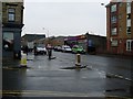
Shettleston Road
At the junction with Fernan Street.
Image: © Stephen Sweeney
Taken: 30 Apr 2009
0.22 miles
4

Former Shettleston Nursery School
A derelict old house within the school grounds, possibly the janitor's house.
Image: © Thomas Nugent
Taken: 26 May 2013
0.22 miles
5
Palaceum
Pub in Edrom Street, Shettleston
Image: © Don Gillies
Taken: 11 Jan 2009
0.24 miles
6

Fernan Street
An unusual concave curved tenement gable end at the corner of Shettleston Road.
Image: © Thomas Nugent
Taken: 26 May 2013
0.24 miles
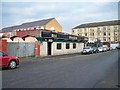
7

Disused building on Fernan Street
Possibly former social services offices.
Image: © Thomas Nugent
Taken: 26 May 2013
0.25 miles