IMAGES TAKEN NEAR TO
Cardowan Road, GLASGOW, G32 6QP
Introduction
This page details the photographs taken nearby to Cardowan Road, G32 6QP by members of the Geograph project.
The Geograph project started in 2005 with the aim of publishing, organising and preserving representative images for every square kilometre of Great Britain, Ireland and the Isle of Man.

There are currently over 7.5m images from over14,400 individuals and you can help contribute to the project by visiting https://www.geograph.org.uk
Image Map
Images are licensed for reuse under creativecommons.org/licenses/by-sa/2.0
Notes
- Clicking on the map will re-center to the selected point.
- The higher the marker number, the further away the image location is from the centre of the postcode.
Image Listing (23 Images Found)
Images are licensed for reuse under creativecommons.org/licenses/by-sa/2.0
Image
Details
Distance
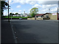
1
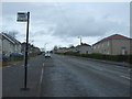
Bus stop on Carntynehall Road
Looking north.
Image: © JThomas
Taken: 30 Mar 2017
0.13 miles
4
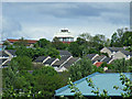
Cranhill water tower
The massive water tower Image, viewed from Carntyne railway station.
Image: © Thomas Nugent
Taken: 26 May 2013
0.15 miles

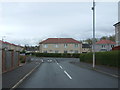
6

Carntynehall Road
Near Carntyne railway station.
Image: © Thomas Nugent
Taken: 26 May 2013
0.18 miles
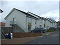
7
Carntynehall Road
A wide stretch of road, near Carntyne railway station.
Image: © Thomas Nugent
Taken: 26 May 2013
0.18 miles
8
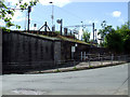
Carntyne railway station
The access ramp to Platform 2 from Carntynehall Road.
Image: © Thomas Nugent
Taken: 26 May 2013
0.19 miles
9
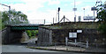
Carntyne railway station
Viewed from Carntynehall Road.
Image: © Thomas Nugent
Taken: 26 May 2013
0.19 miles
10
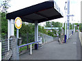
Carntyne railway station
The ramp between Platform 2 and Carntynehall Road.
Image: © Thomas Nugent
Taken: 26 May 2013
0.20 miles