IMAGES TAKEN NEAR TO
Inverleith Street, GLASGOW, G32 6GA
Introduction
This page details the photographs taken nearby to Inverleith Street, G32 6GA by members of the Geograph project.
The Geograph project started in 2005 with the aim of publishing, organising and preserving representative images for every square kilometre of Great Britain, Ireland and the Isle of Man.

There are currently over 7.5m images from over14,400 individuals and you can help contribute to the project by visiting https://www.geograph.org.uk
Image Map
Images are licensed for reuse under creativecommons.org/licenses/by-sa/2.0
Notes
- Clicking on the map will re-center to the selected point.
- The higher the marker number, the further away the image location is from the centre of the postcode.
Image Listing (7 Images Found)
Images are licensed for reuse under creativecommons.org/licenses/by-sa/2.0
Image
Details
Distance
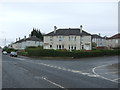

3
Bengairn Street at Todd Street Haghill Glasgow
Once a Glasgow City Council housing scheme of flats the area has been cleared for several years. Some development has taken place further North on Todd Street with new low rise houses built. 12th August 2009
Image: © Gordon Dowie
Taken: 12 Aug 2009
0.22 miles
4
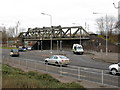
Railway Bridge near the Forge
Carries the Glasgow to Coatbridge railway line.
Image: © G Laird
Taken: 13 Feb 2010
0.23 miles

6

South Carntyne Church
On Carntyne Road, Glasgow.
Image: © G Laird
Taken: 3 Apr 2010
0.24 miles
