IMAGES TAKEN NEAR TO
Myreside Street, GLASGOW, G32 6DX
Introduction
This page details the photographs taken nearby to Myreside Street, G32 6DX by members of the Geograph project.
The Geograph project started in 2005 with the aim of publishing, organising and preserving representative images for every square kilometre of Great Britain, Ireland and the Isle of Man.

There are currently over 7.5m images from over14,400 individuals and you can help contribute to the project by visiting https://www.geograph.org.uk
Image Map
Images are licensed for reuse under creativecommons.org/licenses/by-sa/2.0
Notes
- Clicking on the map will re-center to the selected point.
- The higher the marker number, the further away the image location is from the centre of the postcode.
Image Listing (4 Images Found)
Images are licensed for reuse under creativecommons.org/licenses/by-sa/2.0
Image
Details
Distance

2

South Carntyne Church
On Carntyne Road, Glasgow.
Image: © G Laird
Taken: 3 Apr 2010
0.24 miles

4
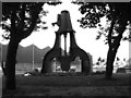
The Steam Hammer
This Steam Hammer can be found at the corner of Shettleston Road and Westmuir Street in Parkhead, Shettleston Road can be seen beyond the Steam Hammer.
What is a Steam Hammer
A Steam hammer is a power-driven hammer that is used to make heavy forgings. The hammer head is raised by the pressure of steam that is admitted into the lower part of a cylinder connected to the head. When the hammer reaches the desired height, the steam is released and the hammer falls. Steam admitted into the upper part of the cylinder increases the speed of the fall. The speed of the hammer's fall also determines its force. Steam hammers vary in weight from 100 pounds (45 kilograms) to 100 tons (91 metric tons).
Image: © Stevie Spiers
Taken: 21 Sep 2007
0.25 miles