IMAGES TAKEN NEAR TO
Carntynehall Road, GLASGOW, G32 6AH
Introduction
This page details the photographs taken nearby to Carntynehall Road, G32 6AH by members of the Geograph project.
The Geograph project started in 2005 with the aim of publishing, organising and preserving representative images for every square kilometre of Great Britain, Ireland and the Isle of Man.

There are currently over 7.5m images from over14,400 individuals and you can help contribute to the project by visiting https://www.geograph.org.uk
Image Map
Images are licensed for reuse under creativecommons.org/licenses/by-sa/2.0
Notes
- Clicking on the map will re-center to the selected point.
- The higher the marker number, the further away the image location is from the centre of the postcode.
Image Listing (33 Images Found)
Images are licensed for reuse under creativecommons.org/licenses/by-sa/2.0
Image
Details
Distance
1
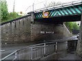
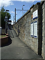
Free Palestine
Graffiti - though many would disagree with that term - on the wall beneath the railway bridge over Carntynehall Road.
Image: © Stephen Sweeney
Taken: 30 Apr 2009
0.01 miles
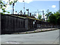
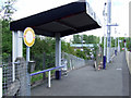
2
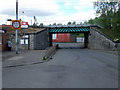
Carntyne railway station
Looking north on Carntynehall Road.
Image: © Thomas Nugent
Taken: 26 May 2013
0.04 miles
3
Carntyne railway station
Looking north on Carntynehall Road.
Image: © Thomas Nugent
Taken: 26 May 2013
0.04 miles
4
Carntyne railway station
Looking east from Platform 2.
Image: © Thomas Nugent
Taken: 26 May 2013
0.04 miles
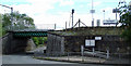
5
Carntyne railway station
The ramp leading to Platform 1 from Carntynehall Road.
Image: © Thomas Nugent
Taken: 26 May 2013
0.04 miles
6
Carntyne railway station
The access ramp to Platform 2 from Carntynehall Road.
Image: © Thomas Nugent
Taken: 26 May 2013
0.05 miles
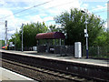
7
Carntyne railway station
Viewed from Carntynehall Road.
Image: © Thomas Nugent
Taken: 26 May 2013
0.05 miles
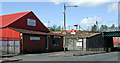
8
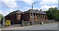
Former Shettleston Nursery School
The former Shettleston Nursery School on Old Shettleston Road. The school was built in 1868 and became Shettleston Primary School in 1949 but reverted to Shettleston Nursery School in 1961. Currently occupied by Belvins Shopfitters Ltd http://blevinsltd.co.uk/ .
Image: © Thomas Nugent
Taken: 26 May 2013
0.06 miles
9
Carntyne railway station
The ramp between Platform 2 and Carntynehall Road.
Image: © Thomas Nugent
Taken: 26 May 2013
0.06 miles
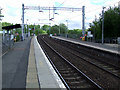
10
Carntyne railway station
Platform 1, the west bound platform.
Image: © Thomas Nugent
Taken: 26 May 2013
0.06 miles