IMAGES TAKEN NEAR TO
Carrick Drive, GLASGOW, G32 0RW
Introduction
This page details the photographs taken nearby to Carrick Drive, G32 0RW by members of the Geograph project.
The Geograph project started in 2005 with the aim of publishing, organising and preserving representative images for every square kilometre of Great Britain, Ireland and the Isle of Man.

There are currently over 7.5m images from over14,400 individuals and you can help contribute to the project by visiting https://www.geograph.org.uk
Image Map
Images are licensed for reuse under creativecommons.org/licenses/by-sa/2.0
Notes
- Clicking on the map will re-center to the selected point.
- The higher the marker number, the further away the image location is from the centre of the postcode.
Image Listing (11 Images Found)
Images are licensed for reuse under creativecommons.org/licenses/by-sa/2.0
Image
Details
Distance
1
Corsewall Avenue
Residential area of Mount Vernon.
Image: © Stephen Sweeney
Taken: 30 Apr 2009
0.12 miles
2
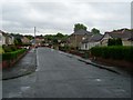
Muirside Avenue
Residential street in Mount Vernon.
Image: © Stephen Sweeney
Taken: 30 Apr 2009
0.12 miles
3
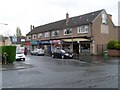
Mount Vernon shops
On Central Avenue.
Image: © Stephen Sweeney
Taken: 30 Apr 2009
0.14 miles
4
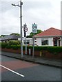
Slightly ambiguous road signs in Mount Vernon
30 and 20 appear side by side at this road entrance. They of course mean that the legal limit is 30mph, but drivers are advised to keep to 20 when in the scheme.
Image: © Stephen Sweeney
Taken: 30 Apr 2009
0.16 miles
5
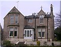
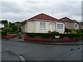
Fire-Damaged House, Mount Vernon
On Bowling Green Road
Image: © Chris Upson
Taken: 10 Mar 2006
0.17 miles
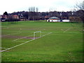
7
Mount Vernon Park
Looking in off Kenmuir Avenue.
Image: © Stephen Sweeney
Taken: 30 Apr 2009
0.18 miles
8
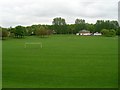
Mount Vernon Park
In the East End of Glasgow.
Image: © Stephen Sweeney
Taken: 30 Apr 2009
0.20 miles
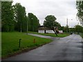
9
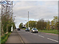
Communication Masts on Mount Vernon Avenue
Sherbourne Park is on the right.
Image: © wrobison
Taken: 20 Apr 2024
0.20 miles
10
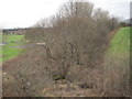
Former Glasgow, Bothwell, Hamilton & Coatbridge Railway line
Looking towards the former Mount Vernon North station (1878-1955) and Shettleston. Part of the North British Railway.
Image: © Nigel Thompson
Taken: 9 Feb 2017
0.21 miles