IMAGES TAKEN NEAR TO
Croftspar Place, GLASGOW, G32 0JD
Introduction
This page details the photographs taken nearby to Croftspar Place, G32 0JD by members of the Geograph project.
The Geograph project started in 2005 with the aim of publishing, organising and preserving representative images for every square kilometre of Great Britain, Ireland and the Isle of Man.

There are currently over 7.5m images from over14,400 individuals and you can help contribute to the project by visiting https://www.geograph.org.uk
Image Map
Images are licensed for reuse under creativecommons.org/licenses/by-sa/2.0
Notes
- Clicking on the map will re-center to the selected point.
- The higher the marker number, the further away the image location is from the centre of the postcode.
Image Listing (7 Images Found)
Images are licensed for reuse under creativecommons.org/licenses/by-sa/2.0
Image
Details
Distance
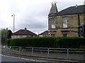
1

Mansionhouse Drive
In the Springboig area of Glasgow.
Image: © Stephen Sweeney
Taken: 21 Apr 2009
0.10 miles

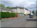
3
Houses on Mansionhouse Drive
In the area of Springboig.
Image: © Stephen Sweeney
Taken: 21 Apr 2009
0.11 miles
4
Larchgrove Avenue flats
In Springboig.
Image: © Stephen Sweeney
Taken: 21 Apr 2009
0.12 miles
5

A small woodland
A wood between Hallhill Road and Mansionhouse Drive, Springboig.
Image: © Richard Webb
Taken: 23 Apr 2012
0.13 miles
6

Double roundabout system in Springboig
At Halhill Road, Springboig Road, Mansionhouse Drive and Gartocher Road.
Image: © Stephen Sweeney
Taken: 21 Apr 2009
0.14 miles
7
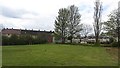
Small park, Springboig
There is a huge burnt area, bonfire site, where the centre circle should be. I have no photograph as the local cider club were meeting in the bushes beside the touchline.
Image: © Richard Webb
Taken: 23 Apr 2012
0.17 miles