IMAGES TAKEN NEAR TO
Crownhall Place, GLASGOW, G32 0AP
Introduction
This page details the photographs taken nearby to Crownhall Place, G32 0AP by members of the Geograph project.
The Geograph project started in 2005 with the aim of publishing, organising and preserving representative images for every square kilometre of Great Britain, Ireland and the Isle of Man.

There are currently over 7.5m images from over14,400 individuals and you can help contribute to the project by visiting https://www.geograph.org.uk
Image Map
Images are licensed for reuse under creativecommons.org/licenses/by-sa/2.0
Notes
- Clicking on the map will re-center to the selected point.
- The higher the marker number, the further away the image location is from the centre of the postcode.
Image Listing (8 Images Found)
Images are licensed for reuse under creativecommons.org/licenses/by-sa/2.0
Image
Details
Distance
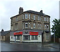
3
The Gartocher Bar in Shettleston
On Shettleston Road.
Image: © JThomas
Taken: 29 Jun 2017
0.18 miles
4
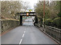
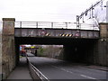
Railway Bridges, Shettleston
On Gartocher Road, this is the reverse view to Image
Image: © G Laird
Taken: 3 Apr 2010
0.23 miles
5
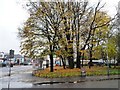
A splash of autumn colour, Shettleston
At the junction of Shettleston Road [A89] and Culross Street.
Image: © Christine Johnstone
Taken: 14 Nov 2012
0.23 miles
6

Eastmuir Lodge 1126, 1543 Shettleston Road
A Freemason's lodge on the former site of Eastmuir School. Founded in 1914, with the foundation stone for this building laid in 1928.
Image: © Christine Johnstone
Taken: 14 Nov 2012
0.23 miles
8
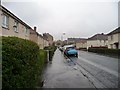
Gatehouse Street, Shettleston
Looking east from the junction with Culross Street.
Image: © Christine Johnstone
Taken: 14 Nov 2012
0.24 miles