IMAGES TAKEN NEAR TO
Muiryfauld Drive, GLASGOW, G31 5RT
Introduction
This page details the photographs taken nearby to Muiryfauld Drive, G31 5RT by members of the Geograph project.
The Geograph project started in 2005 with the aim of publishing, organising and preserving representative images for every square kilometre of Great Britain, Ireland and the Isle of Man.

There are currently over 7.5m images from over14,400 individuals and you can help contribute to the project by visiting https://www.geograph.org.uk
Image Map
Images are licensed for reuse under creativecommons.org/licenses/by-sa/2.0
Notes
- Clicking on the map will re-center to the selected point.
- The higher the marker number, the further away the image location is from the centre of the postcode.
Image Listing (14 Images Found)
Images are licensed for reuse under creativecommons.org/licenses/by-sa/2.0
Image
Details
Distance
1
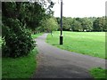
Tollcross Park
A path across the park, with a CCTV camera pole.
Image: © Richard Webb
Taken: 29 Jun 2011
0.09 miles
2
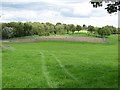
Tollcross Park
A 37Ha park, with some famous gardens.
Image: © Richard Webb
Taken: 29 Jun 2011
0.12 miles
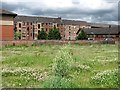
3
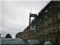
Maukinfauld Road Glasgow
Housing in Maukinfauld Road under repair.
Image: © edward mcmaihin
Taken: 15 May 2011
0.14 miles
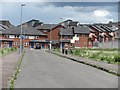
4
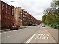
Tollcross Road Glasgow
Looking towards the city centre, Tollcross Park is on the right.
Image: © Gordon Dowie
Taken: 29 Apr 2010
0.20 miles
5
Quarryknowe clover
Clover on the site of a demolished street.
Image: © Richard Webb
Taken: 29 Jun 2011
0.22 miles
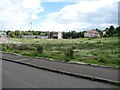
6
Quarryknowe Street
The street runs through undeveloped land, almost certainly the site of demolished buildings, to new housing.
Image: © Richard Webb
Taken: 29 Jun 2011
0.23 miles
7
A vanished street
Clover off Quarryknowe Street, almost certainly the site of demolished buildings.
Image: © Richard Webb
Taken: 29 Jun 2011
0.23 miles
8
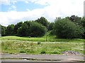
Off Quarryknowe Street
The clover appears to be growing on the site of buildings, now demolished.
Image: © Richard Webb
Taken: 29 Jun 2011
0.23 miles
9
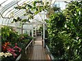
Tollcross Park - inside the Winter Gardens
See: Image
Image: © Lairich Rig
Taken: 3 Feb 2006
0.24 miles
10
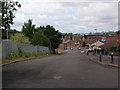
Looking down St Mark Street
The picture was taken from just inside Tollcross Park. It looks west, downhill.
Image: © Alec MacKinnon
Taken: 3 Jul 2016
0.24 miles