IMAGES TAKEN NEAR TO
Duke Street, GLASGOW, G31 5NZ
Introduction
This page details the photographs taken nearby to Duke Street, G31 5NZ by members of the Geograph project.
The Geograph project started in 2005 with the aim of publishing, organising and preserving representative images for every square kilometre of Great Britain, Ireland and the Isle of Man.

There are currently over 7.5m images from over14,400 individuals and you can help contribute to the project by visiting https://www.geograph.org.uk
Image Map
Images are licensed for reuse under creativecommons.org/licenses/by-sa/2.0
Notes
- Clicking on the map will re-center to the selected point.
- The higher the marker number, the further away the image location is from the centre of the postcode.
Image Listing (47 Images Found)
Images are licensed for reuse under creativecommons.org/licenses/by-sa/2.0
Image
Details
Distance
1
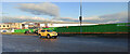
Site of Parkhead Hospital
The relatively short lived hospital opened in 1989 and closed in 2018. A new healthcare facility will be built here.
Image: © Thomas Nugent
Taken: 28 Nov 2021
0.04 miles
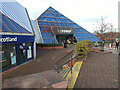
2
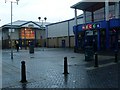
Forge Market, Parkhead
Scotland's largest indoor market.
Image: © Stephen Sweeney
Taken: 23 Jan 2009
0.05 miles
3
Bank of Scotland, Duke Street, Glasgow
On Duke Street (foreground) at East Wellington Street.
Image: © Thomas Nugent
Taken: 3 Jan 2018
0.06 miles
4
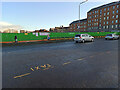
Site of Parkhead Hospital
The relatively short lived hospital opened in 1989 and closed in 2018. A new healthcare facility will be built here.
Image: © Thomas Nugent
Taken: 28 Nov 2021
0.07 miles
5
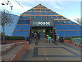
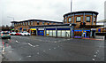
The Forge Shopping Centre
The Duke Street side of the busy shopping and leisure complex.
Image: © Thomas Nugent
Taken: 28 Nov 2021
0.09 miles
6
The Forge Shopping Centre
The Duke Street side of the busy shopping and leisure complex.
Image: © Thomas Nugent
Taken: 28 Nov 2021
0.09 miles
7
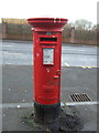
Elizabethan postbox on Duke Street, Glasgow
Outside the former Post Office.
Postbox No. G31 465.
See Image] for context.
Image: © JThomas
Taken: 30 Mar 2017
0.10 miles
8
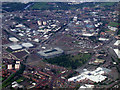
Parkhead from the air
Celtic Park and The Forge shopping centre, with their new neighbours, the Sir Chris Hoy velodrome and the Commonwealth Sports Arena.
Image: © Thomas Nugent
Taken: 9 Jun 2012
0.10 miles
9

Parkhead and the River Clyde from the air
Celtic Park is in the left foreground, Ibrox Stadium can be seen towards the top right.
Image: © Thomas Nugent
Taken: 9 Jun 2012
0.10 miles
10
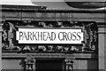
Parkhead Cross (street sign)
This street sign is on a building on Tollcross Road; the street to the left is the start of Duke Street.
WARNING IF TAKING PHOTOGRAPHS IN THIS AREA
While taking this shot I was approached by several locals who thought I was a press photographer. I was advised to be careful as a press photographer the previous day was set upon as he was putting a story together about the locals who were possible drug dealers or benefit fraudsters.
Image: © Stevie Spiers
Taken: 21 Sep 2007
0.14 miles