IMAGES TAKEN NEAR TO
Belvidere Terrace, GLASGOW, G31 4PD
Introduction
This page details the photographs taken nearby to Belvidere Terrace, G31 4PD by members of the Geograph project.
The Geograph project started in 2005 with the aim of publishing, organising and preserving representative images for every square kilometre of Great Britain, Ireland and the Isle of Man.

There are currently over 7.5m images from over14,400 individuals and you can help contribute to the project by visiting https://www.geograph.org.uk
Image Map
Images are licensed for reuse under creativecommons.org/licenses/by-sa/2.0
Notes
- Clicking on the map will re-center to the selected point.
- The higher the marker number, the further away the image location is from the centre of the postcode.
Image Listing (11 Images Found)
Images are licensed for reuse under creativecommons.org/licenses/by-sa/2.0
Image
Details
Distance
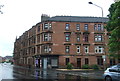
3
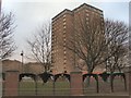
Parkhead
One of two tower blocks of flats, which neighbour the football stadium at Parkhead - home to Glasgow Celtic football club - on the A74.
Image: © Roger May
Taken: 2 Feb 2006
0.14 miles
5
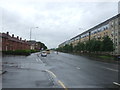
London Road (A74), Parkhead
Looking south east.
Image: © JThomas
Taken: 29 Jun 2017
0.15 miles
6
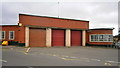
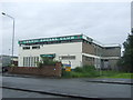
Parkhead Fire Station
Parkhead Fire Station in the east side of Glasgow.
Image: © edward mcmaihin
Taken: 15 May 2011
0.18 miles
8
Clyde Walkway
The picture looks along the Clyde Walkway heading west close to the former Commonwealth Games athletes' village.
Image: © Alec MacKinnon
Taken: 30 Mar 2018
0.22 miles
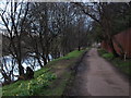
9
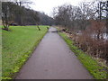
A straight section of the Clyde Walkway
One of the more scenic sections of the Clyde Walkway in this urban vicinity.
Image: © G Laird
Taken: 7 Feb 2010
0.23 miles
10
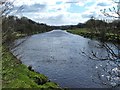
The River Clyde near Parkhead
The picture was taken from beside the footpath and cycle route, which is also part of the Clyde Walkway.
Here, a long straight section of the river flows north-west, towards the photographer's position, as shown on the map. At the time of writing, the map does not depict, at any scale, the power lines that cross the river here, although they, and the associated pylons, can be seen in satellite imagery.
The area on the right is part of a tongue of land enclosed within a loop of the river; it is known as the Cuningar Loop (after Cuningar, the name that large-scale OS mapping applies to the nearest part of the tongue of land; that land is set to become the site of a new woodland park).
Image: © Lairich Rig
Taken: 8 Apr 2005
0.25 miles