IMAGES TAKEN NEAR TO
Springfield Gardens, GLASGOW, G31 4HW
Introduction
This page details the photographs taken nearby to Springfield Gardens, G31 4HW by members of the Geograph project.
The Geograph project started in 2005 with the aim of publishing, organising and preserving representative images for every square kilometre of Great Britain, Ireland and the Isle of Man.

There are currently over 7.5m images from over14,400 individuals and you can help contribute to the project by visiting https://www.geograph.org.uk
Image Map
Images are licensed for reuse under creativecommons.org/licenses/by-sa/2.0
Notes
- Clicking on the map will re-center to the selected point.
- The higher the marker number, the further away the image location is from the centre of the postcode.
Image Listing (116 Images Found)
Images are licensed for reuse under creativecommons.org/licenses/by-sa/2.0
Image
Details
Distance
1
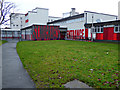
St Michael's Primary School
On Springfield Street. I think this might be the entrance.
School web site : http://www.st-michaels-pri.glasgow.sch.uk/ .
Image: © Thomas Nugent
Taken: 3 Jan 2018
0.06 miles
2
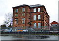
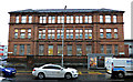
Former Newlands Public School
A traditional red sandstone 'School Board of Glasgow' building, on Springfield Street. Now occupied by Glasgow City Council Social Work department.
Image: © Thomas Nugent
Taken: 3 Jan 2018
0.06 miles
3
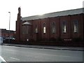
St Michael's Church, Parkhead
On the Gallowgate.
Image: © Stephen Sweeney
Taken: 19 Jan 2008
0.06 miles
4
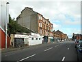
Gallowgate
Looking towards Parkhead Cross.
Image: © Richard Sutcliffe
Taken: 4 Sep 2022
0.07 miles
5
Former Newlands Public School
A traditional red sandstone 'School Board of Glasgow' building, on Springfield Street. Now occupied by Glasgow City Council Social Work department.
Image: © Thomas Nugent
Taken: 3 Jan 2018
0.08 miles
6
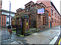
Former Newlands Public School
The now disused janitor's house. The main building is now occupied by Glasgow City Council Social Work department.
See also Image & Image
Image: © Thomas Nugent
Taken: 3 Jan 2018
0.08 miles
7
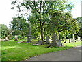
Gravestones, Eastern Necropolis
The eastern side of the cemetery has a lot of trees growing amongst the gravestones. The cemetery was laid out in 1847 and is Category B listed http://portal.historicenvironment.scot/designation/LB33633.
Image: © Richard Sutcliffe
Taken: 4 Sep 2022
0.09 miles
8
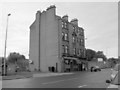
The Old Black Bull
This pub can be found close to The Forge shopping mall in Parkhead.
Image: © Stevie Spiers
Taken: 21 Sep 2007
0.10 miles
9
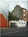
Spicy Flavour and Calton Athletic, Gallowgate
Spicy Flavour was a takeaway, which has been closed for many years and the vegetation has taken over. Calton Athletic is an addiction treatment centre.
Image: © Richard Sutcliffe
Taken: 4 Sep 2022
0.11 miles
10
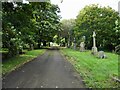
Road, Eastern Necropolis
The eastern side of the cemetery has a lot of trees growing amongst the gravestones. The cemetery was laid out in 1847 and is Category B listed http://portal.historicenvironment.scot/designation/LB33633.
Image: © Richard Sutcliffe
Taken: 4 Sep 2022
0.11 miles