IMAGES TAKEN NEAR TO
Newbank Road, GLASGOW, G31 4HA
Introduction
This page details the photographs taken nearby to Newbank Road, G31 4HA by members of the Geograph project.
The Geograph project started in 2005 with the aim of publishing, organising and preserving representative images for every square kilometre of Great Britain, Ireland and the Isle of Man.

There are currently over 7.5m images from over14,400 individuals and you can help contribute to the project by visiting https://www.geograph.org.uk
Image Map
Images are licensed for reuse under creativecommons.org/licenses/by-sa/2.0
Notes
- Clicking on the map will re-center to the selected point.
- The higher the marker number, the further away the image location is from the centre of the postcode.
Image Listing (6 Images Found)
Images are licensed for reuse under creativecommons.org/licenses/by-sa/2.0
Image
Details
Distance
1
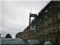
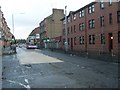
Maukinfauld Road Glasgow
Housing in Maukinfauld Road under repair.
Image: © edward mcmaihin
Taken: 15 May 2011
0.14 miles
2
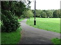
Tollcross Park
A path across the park, with a CCTV camera pole.
Image: © Richard Webb
Taken: 29 Jun 2011
0.20 miles
3
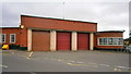
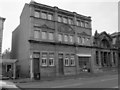
Parkhead Fire Station
Parkhead Fire Station in the east side of Glasgow.
Image: © edward mcmaihin
Taken: 15 May 2011
0.22 miles
4
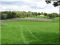
Tollcross Park
A 37Ha park, with some famous gardens.
Image: © Richard Webb
Taken: 29 Jun 2011
0.22 miles
6
Corporation Public Baths & Wash House
This building used to be the Corporation Public Baths & Wash House, it is connected to Parkhead Public Library, it is the smaller building on the right of the photograph, this building can be found on Tollcross Road near Parkhead Cross.
Image: © Stevie Spiers
Taken: 21 Sep 2007
0.23 miles