IMAGES TAKEN NEAR TO
Stamford Gate, GLASGOW, G31 4BA
Introduction
This page details the photographs taken nearby to Stamford Gate, G31 4BA by members of the Geograph project.
The Geograph project started in 2005 with the aim of publishing, organising and preserving representative images for every square kilometre of Great Britain, Ireland and the Isle of Man.

There are currently over 7.5m images from over14,400 individuals and you can help contribute to the project by visiting https://www.geograph.org.uk
Image Map
Images are licensed for reuse under creativecommons.org/licenses/by-sa/2.0
Notes
- Clicking on the map will re-center to the selected point.
- The higher the marker number, the further away the image location is from the centre of the postcode.
Image Listing (156 Images Found)
Images are licensed for reuse under creativecommons.org/licenses/by-sa/2.0
Image
Details
Distance
1
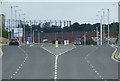
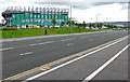
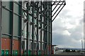
East End Regeneration Route
A new road to help link the East End with the M74. The gas holders are at Provan Gas Works Image
Image: © Thomas Nugent
Taken: 14 Jul 2012
0.03 miles
2
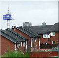
Forge Retail Park sign
Visible above the houses from London Road.
Image: © Thomas Nugent
Taken: 14 Jul 2012
0.04 miles
3
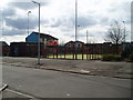
Outdoor 5 a side pitch
Provided as part of the improvements to Camlachie area of Glasgow. The area has had millions of pounds of investment over the last 10 years to demolish poor quality City Council flats. There are now over 400 new low rise family houses and a few modern flats. The last of the original flats can be seen behind the pitch. Along with a block containing the West of Scotland Housing Association offices which are out of picture on the right, these are due to be demolished in the next few months. 9th April 4.30pm.
Image: © Gordon Dowie
Taken: 9 Apr 2010
0.05 miles
4
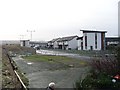
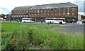
New housing in Parkhead
An attempt to rejuvenate this traditionally run-down area.
Image: © Stephen Sweeney
Taken: 19 Jan 2008
0.07 miles
5
Celtic Park
The Jock Stein stand, viewed across the A728 Clyde Gateway. Jock Stein managed the Celtic team which, in 1967, became the first British club to win the European Cup.
Image: © Thomas Nugent
Taken: 15 Aug 2015
0.10 miles
6
Car park at Celtic Park
Looking to the Camlachie flats.
Image: © Stephen Sweeney
Taken: 19 Jan 2008
0.12 miles
7
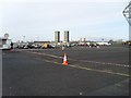
Holywell Street
An industrial building, to the north of Celtic Park, hence the coaches as it's a match day.
Image: © Thomas Nugent
Taken: 15 Aug 2015
0.12 miles
8
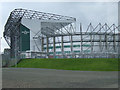
Celtic Park
The Jock Stein stand at the west end of the stadium. John "Jock" Stein http://en.wikipedia.org/wiki/Jock_Stein was the manager of Celtic FC in 1967 when they became the first British club to win the European Cup.
Image: © Thomas Nugent
Taken: 14 Jul 2012
0.13 miles
9
Celtic Park
This picture shows part of the south west stand which is also known as the Jock Stein Stand. http://en.wikipedia.org/wiki/Jock_Stein
Image: © Paul McIlroy
Taken: 16 Jul 2007
0.13 miles
10
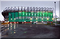
Celtic Park
The Jock Stein Stand at the west end of the stadium.
Image: © Thomas Nugent
Taken: 3 Jan 2018
0.13 miles