IMAGES TAKEN NEAR TO
Crinan Street, GLASGOW, G31 3JN
Introduction
This page details the photographs taken nearby to Crinan Street, G31 3JN by members of the Geograph project.
The Geograph project started in 2005 with the aim of publishing, organising and preserving representative images for every square kilometre of Great Britain, Ireland and the Isle of Man.

There are currently over 7.5m images from over14,400 individuals and you can help contribute to the project by visiting https://www.geograph.org.uk
Image Map
Images are licensed for reuse under creativecommons.org/licenses/by-sa/2.0
Notes
- Clicking on the map will re-center to the selected point.
- The higher the marker number, the further away the image location is from the centre of the postcode.
Image Listing (30 Images Found)
Images are licensed for reuse under creativecommons.org/licenses/by-sa/2.0
Image
Details
Distance


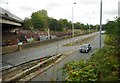
3
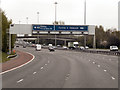
M8, Glasgow
Note the typical “Glasgow-type” sign gantry giving advance notice of the next junction (junction 13). With the following distinctive elements:
• Near and offside support legs (basically 2 rectangular hollow sections with base plates to allow connections to the foundations)
• A Main Frame (made up of rectangular hollow sections) - Over clad on the front and rear.
• A Sub Frame (made up of smaller hollow sections and welded to main frame).
• A Sign Face - acrylic sheets hung from the front of the sub frame over its full height.
• Internal Electrics - sign lighting provided through the use of several dozen fluorescent battens.
Gantries of this type were erected as part of the construction of the Kingston Bridge and its approach roads in 1970 and they are now a familiar sight on the network around Glasgow.
More information on “Glasgow Style Gantries” at http://www.glasgows-motorways.co.uk/glasgow-gantries/4578281645 (Glasgow’s Motorways)
Image: © David Dixon
Taken: 20 Apr 2012
0.07 miles
5
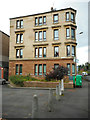
Tenement, Harcourt Drive
An unusual combination of red and yellow sandstone.
Image: © Richard Sutcliffe
Taken: 23 Aug 2019
0.11 miles
6
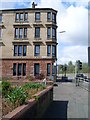
Harcourt Drive tenements
Near to Alexandra Parade railway station.
Image: © Stephen Sweeney
Taken: 21 Apr 2009
0.11 miles
7
Viewpark Avenue
The M8 motorway is above to the left. Just beyond the road is the railway line which runs through Alexander Parade station a few hundred metres to the southeast.
Image: © Richard Sutcliffe
Taken: 23 Aug 2019
0.13 miles
8
Burnfield Builders & Demolishers Ltd
Seen from across Alexandra Park Street.
Image: © Richard Sutcliffe
Taken: 23 Aug 2019
0.14 miles
9
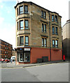
Corner tenement, Harcourt Drive
The ground floor is constructed out of red sandstone, but presumably the stonework is in poor condition, as it has been over-painted to give the same effect. The shop is the Milnbank Recycling Centre.
Image: © Richard Sutcliffe
Taken: 23 Aug 2019
0.15 miles
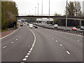
10
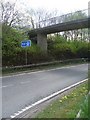
M8 slipway
The westbound slipway at junction 14.
Image: © Stephen Sweeney
Taken: 21 Apr 2009
0.16 miles