IMAGES TAKEN NEAR TO
Alexandra Parade, GLASGOW, G31 2ET
Introduction
This page details the photographs taken nearby to Alexandra Parade, G31 2ET by members of the Geograph project.
The Geograph project started in 2005 with the aim of publishing, organising and preserving representative images for every square kilometre of Great Britain, Ireland and the Isle of Man.

There are currently over 7.5m images from over14,400 individuals and you can help contribute to the project by visiting https://www.geograph.org.uk
Image Map
Images are licensed for reuse under creativecommons.org/licenses/by-sa/2.0
Notes
- Clicking on the map will re-center to the selected point.
- The higher the marker number, the further away the image location is from the centre of the postcode.
Image Listing (372 Images Found)
Images are licensed for reuse under creativecommons.org/licenses/by-sa/2.0
Image
Details
Distance
1
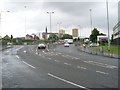
Castle Street becomes the "Ally Parade"
Alexandra Parade runs from this point of origin through a substantial area of Glasgow's East End, to Alexandra Park, at which point it becomes Cumbernauld Road and Edinburgh Road.
Image: © Stephen Sweeney
Taken: 19 Jun 2008
0.01 miles
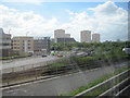
2
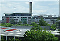
Glasgow Royal Infirmary
Viewed from the motorway footbridge at North Wallace Street.
Image: © Thomas Nugent
Taken: 5 Jun 2012
0.02 miles
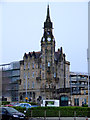
3
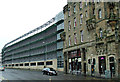
Glasgow Royal Infirmary multi storey car park
No attempt appears to have been made to make this building complement the neighbouring former Blind Asylum Image or the surrounding Royal Infirmary buildings in general.
Image: © Thomas Nugent
Taken: 5 Nov 2013
0.04 miles
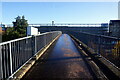
4
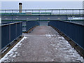
Footbridge to Castle Street
Crosses Springburn Road and Stirling Road from Parson Street. The Royal Infirmary car park is in the background.
Image: © Thomas Nugent
Taken: 9 Jan 2011
0.04 miles
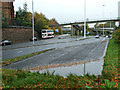
5
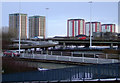
Townhead interchange
With the Charles Street highrise blocks in the background. Viewed from the Castle Street footbridge.
Image: © Thomas Nugent
Taken: 9 Jan 2011
0.05 miles
6
M8 junction 15 looking south
The road on the left is Castle Street. From westbound M8
Image: © John Firth
Taken: 9 May 2011
0.05 miles
7
Glasgow Royal Infirmary
Part of the old frontage on Castle Street is now surrounded by a multi-storey car park.
Image: © Thomas Nugent
Taken: 9 Jan 2011
0.05 miles
8
Turf zone TheRiverKwai
Footbridge at Junction 15, M8, Glasgow.
Image: © Ian S
Taken: 12 Nov 2023
0.05 miles
9
Townhead road to nowhere
The short stub of road in the foreground was to have been part of the cancelled M8 inner ring road http://www.sabre-roads.org.uk/wiki/index.php?title=Townhead_Interchange .
Image: © Thomas Nugent
Taken: 5 Nov 2013
0.06 miles
10
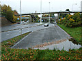
Townhead road to nowhere
The short stub of road in the foreground was to have been part of the cancelled M8 inner ring road http://www.sabre-roads.org.uk/wiki/index.php?title=Townhead_Interchange .
Image: © Thomas Nugent
Taken: 5 Nov 2013
0.06 miles