IMAGES TAKEN NEAR TO
Holland Street, GLASGOW, G2 4NB
Introduction
This page details the photographs taken nearby to Holland Street, G2 4NB by members of the Geograph project.
The Geograph project started in 2005 with the aim of publishing, organising and preserving representative images for every square kilometre of Great Britain, Ireland and the Isle of Man.

There are currently over 7.5m images from over14,400 individuals and you can help contribute to the project by visiting https://www.geograph.org.uk
Image Map
Images are licensed for reuse under creativecommons.org/licenses/by-sa/2.0
Notes
- Clicking on the map will re-center to the selected point.
- The higher the marker number, the further away the image location is from the centre of the postcode.
Image Listing (841 Images Found)
Images are licensed for reuse under creativecommons.org/licenses/by-sa/2.0
Image
Details
Distance
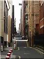
1
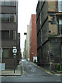
Bath Lane
Viewed across Holland Street.
Image: © Thomas Nugent
Taken: 17 May 2014
0.01 miles
2
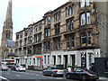
Holland Street
Attractive townhouses between West Regent Street and Bath Lane.
Image: © Thomas Nugent
Taken: 6 Sep 2014
0.01 miles
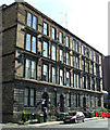
3
Holland Street
The olde buildings are part of the former Glasgow Academy, which became Glasgow High School. A Category A Listed group of buildings http://data.historic-scotland.gov.uk/pls/htmldb/f?p=2200:15:0::::BUILDING:33022 .
Image: © Thomas Nugent
Taken: 3 May 2014
0.02 miles
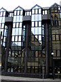
4
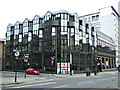
Bath Street
A modern office block at the corner of Holland Street.
Image: © Thomas Nugent
Taken: 3 May 2014
0.03 miles
5
Changing levels at Bath Lane
Looking west from Elmbank Street up Bath Lane.
Image: © Ian Paterson
Taken: 20 Apr 2010
0.03 miles
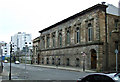
6
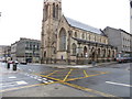
St. Columba's, Glasgow
Popularly known as "Highland Cathedral", St. Columba's was built on this site in 1904, following compensation received from the Caledonian Railway Company which had purchased its former site in Hope Street in order to construct Central Station. St. Columba's was constructed to meet the needs of Glasgow's growing Gaelic-speaking population and still has a Gaelic service every Sunday.
Image: © Euan Nelson
Taken: 19 Apr 2017
0.03 miles
7
Bath Street reflections
St Stephen's Renfield Church reflected in St Stephen's House, an office block on the opposite side of Bath street.
Image: © Thomas Nugent
Taken: 5 Jan 2013
0.03 miles
8
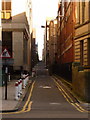
Glasgow: Bath Lane
In the gridded pattern of Glasgow city centre streets, narrow alleyways providing service access run between the main streets that run west-east. They are generally named after the parallel street to the north, with Lane substituted for Street. Thus, here we have Bath Lane, running to the south of Bath Street.
Image: © Chris Downer
Taken: 25 Sep 2010
0.04 miles
9
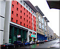
Hotel Ibis and Novotel
On West Regent Street, west of Blythswood Square.
Image: © Thomas Nugent
Taken: 20 Nov 2011
0.04 miles
10
Bath Street
Just west of the gap site at the corner of Pitt Street.
Renfield St Stephen's Church can be seen in the background http://www.scotlandschurchestrust.org.uk/church/renfield-st-stephens-parish-church-glasgow .
Image: © Thomas Nugent
Taken: 5 Jan 2013
0.04 miles