IMAGES TAKEN NEAR TO
Lindrick Drive, GLASGOW, G23 5QR
Introduction
This page details the photographs taken nearby to Lindrick Drive, G23 5QR by members of the Geograph project.
The Geograph project started in 2005 with the aim of publishing, organising and preserving representative images for every square kilometre of Great Britain, Ireland and the Isle of Man.

There are currently over 7.5m images from over14,400 individuals and you can help contribute to the project by visiting https://www.geograph.org.uk
Image Map
Images are licensed for reuse under creativecommons.org/licenses/by-sa/2.0
Notes
- Clicking on the map will re-center to the selected point.
- The higher the marker number, the further away the image location is from the centre of the postcode.
Image Listing (16 Images Found)
Images are licensed for reuse under creativecommons.org/licenses/by-sa/2.0
Image
Details
Distance
1
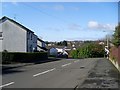
Hollinwell Road
Residential street in Summerston.
Image: © Stephen Sweeney
Taken: 25 Mar 2009
0.05 miles
2
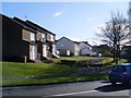
Dougalston Road housing
From Arrochar Street.
Image: © Stephen Sweeney
Taken: 25 Mar 2009
0.05 miles
3
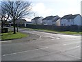
Arrochar Street at Invershiel Road
Road junction in Summerston.
Image: © Stephen Sweeney
Taken: 25 Mar 2009
0.07 miles
4
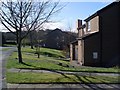
Houses on Arrochar Street
Arrochar Street is the main road through the area of Summerston in North Glasgow.
Image: © Stephen Sweeney
Taken: 25 Mar 2009
0.12 miles
5
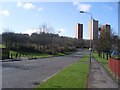
Maryhill high flats from Arrochar Street
In Summerston.
Image: © Stephen Sweeney
Taken: 25 Mar 2009
0.18 miles
6
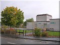
Caldercuilt Nursery School
Nursery school in Summerston, north Glasgow
Image: © Chris Upson
Taken: 26 Sep 2005
0.19 miles
8
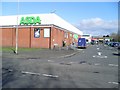
Asda, Summerston
Supermarket in the north of Glasgow.
Image: © Stephen Sweeney
Taken: 25 Mar 2009
0.21 miles
9
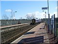
Train leaving Summerston station
Bound for Glasgow Queen Street.
Image: © Stephen Sweeney
Taken: 25 Mar 2009
0.23 miles
10
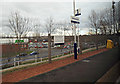
Summerston railway station
On the Maryhill line, between Maryhill and Gilshochill stations.
Image: © Thomas Nugent
Taken: 1 Mar 2014
0.23 miles