IMAGES TAKEN NEAR TO
Skirsa Place, GLASGOW, G23 5EE
Introduction
This page details the photographs taken nearby to Skirsa Place, G23 5EE by members of the Geograph project.
The Geograph project started in 2005 with the aim of publishing, organising and preserving representative images for every square kilometre of Great Britain, Ireland and the Isle of Man.

There are currently over 7.5m images from over14,400 individuals and you can help contribute to the project by visiting https://www.geograph.org.uk
Image Map
Images are licensed for reuse under creativecommons.org/licenses/by-sa/2.0
Notes
- Clicking on the map will re-center to the selected point.
- The higher the marker number, the further away the image location is from the centre of the postcode.
Image Listing (13 Images Found)
Images are licensed for reuse under creativecommons.org/licenses/by-sa/2.0
Image
Details
Distance
1
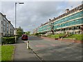
Skirsa Street
The refurbishment shown taking place here is intended to make the homes more energy-efficient.
The streets in this area are named after places in the Shetlands.
Image: © Lairich Rig
Taken: 1 Oct 2012
0.05 miles
2
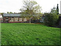
Cadder Community Education Centre
When this picture was taken, the existing community centre included the building shown here, and the one that is partly visible to its left; however, a new Community Centre and Sports Hall are being planned.
The existing buildings are accessed from Fara Street, and they lie between Skirsa Street (from which the picture was taken) and Tresta Road (on these street-names, see Image).
Image: © Lairich Rig
Taken: 1 Oct 2012
0.12 miles
3
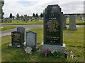
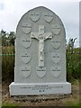
Memorial to Benny Lynch
This is the memorial of the boxer Benny Lynch, "undefeated Flyweight Champion of the World, the first Scotsman to win a world boxing title". It also commemorates his son.
Image: © Lairich Rig
Taken: 1 Oct 2012
0.19 miles
4
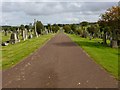
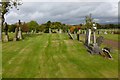
St Kentigern's R.C. Cemetery
This is a view east from near the Image
Image: © Lairich Rig
Taken: 1 Oct 2012
0.19 miles
5
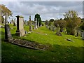
St Kentigern's R.C. Cemetery
The picture was taken near the south-western corner of the cemetery.
Image: © Lairich Rig
Taken: 1 Oct 2012
0.20 miles
6
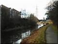
Forth and Clyde Canal
Looking west from beside the Lambhill Bridge.
Image: © Richard Sutcliffe
Taken: 19 Jan 2023
0.22 miles
7
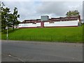
Cadder Primary School
On Herma Street, Glasgow.
Image: © G Laird
Taken: 23 Oct 2010
0.22 miles
8
St Kentigern's R.C. Cemetery
This is a view north from the path shown in Image
Image: © Lairich Rig
Taken: 1 Oct 2012
0.22 miles
9
Memorial for the Cadder Pit Disaster
"Erected in memory of the miners who perished in the Cadder Pit Disaster 3rd August 1913"
Owen McAloon / Thomas Holland
John Worthington / Patrick Darrach
Hugh McCann / George McMillan
Charles Reilly / James Flynn
George Harvey / Patrick Duffin / Patrick Regan
See Image for a view of the memorial in context.
According to an information panel near the Cemetery's entrance, "the worst pit disaster in the area happened on an early morning shift in 1913 when 22 miners were killed in the Cadder Pit no. 15 .... A collective memorial for the eleven Catholic miners was erected in St Kentigern's RC Cemetery, and individual stones were raised for the others in Lambhill Cemetery".
Detailed accounts of the disaster and its aftermath are given at http://scottishmining.co.uk/21.html (at the Scottish Mining website).
Pit 15 was located at about Image The pit 17 that is mentioned several times in the reports was located at about Image I have given those locations here because a few sources (although not the website just cited) erroneously place the scene of the disaster in what is now an area of woodland (Image) not far to the south of the cemetery. The pits are shown and numbered on the relevant 25-inch-to-the-mile OS maps (Pit 15 on Lanarkshire Sheet 001.09 & 10, and Pit 17 on Lanarkshire Sheet 001.11, all of these maps being published in 1912).
Image: © Lairich Rig
Taken: 1 Oct 2012
0.22 miles
10
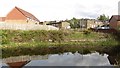
Forth and Clyde Canal
Looking over the water to some new houses in Lambhill.
Image: © Richard Webb
Taken: 9 May 2012
0.23 miles