IMAGES TAKEN NEAR TO
Skirsa Street, GLASGOW, G23 5DH
Introduction
This page details the photographs taken nearby to Skirsa Street, G23 5DH by members of the Geograph project.
The Geograph project started in 2005 with the aim of publishing, organising and preserving representative images for every square kilometre of Great Britain, Ireland and the Isle of Man.

There are currently over 7.5m images from over14,400 individuals and you can help contribute to the project by visiting https://www.geograph.org.uk
Image Map
Images are licensed for reuse under creativecommons.org/licenses/by-sa/2.0
Notes
- Clicking on the map will re-center to the selected point.
- The higher the marker number, the further away the image location is from the centre of the postcode.
Image Listing (34 Images Found)
Images are licensed for reuse under creativecommons.org/licenses/by-sa/2.0
Image
Details
Distance
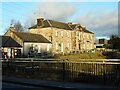
1
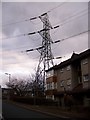
The houses at the east end of Skirsa Street are under the shadow of the electricity pylon
Image: © Elliott Simpson
Taken: 27 Jan 2011
0.03 miles
2
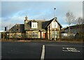
Watchmen's Cottage
Glasgow Corporation Waterworks' watchmen's cottage beside the traffic lights on Balmore Road. A valve chamber is located on the line of the Craigmaddie water mains pipes taking water into Glasgow just to the north; and the pipes pass under the Forth and Clyde Canal just to the south.
Image: © Richard Sutcliffe
Taken: 19 Jan 2023
0.06 miles
3
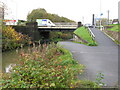
Lambhill Bridge
This bridge carries Balmore Road (A879) across the Forth and Clyde Canal. Some of the history of this and the previous Lambhill Bridge can be found in http://www.scotlandsplaces.gov.uk/search_item/index.php?service=RCAHMS&id=79348.
This is also the reverse view to Image
Image: © G Laird
Taken: 23 Oct 2010
0.07 miles
4
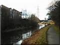
Forth and Clyde Canal
Looking west from beside the Lambhill Bridge.
Image: © Richard Sutcliffe
Taken: 19 Jan 2023
0.07 miles
5
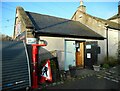
Bike Hub
At Lambhill Stables Image The Bike Hub provides affordable sales and servicing, repairs and bike hire.
Image: © Richard Sutcliffe
Taken: 19 Jan 2023
0.07 miles
6
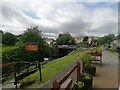
Balmore Road crosses the Forth and Clyde canal
The picture is taken from the front of the Lambhill Stables (Image), looking towards the Lambhill bridge that crosses the canal. The canal and towpath are just below and the Cafe on the Canal sign is no doubt positioned to catch the eye of walkers and cyclists using the old towpath, now part of National Cycle Route 754. At time of writing the cafe is closed due to the pandemic.
Image: © Alec MacKinnon
Taken: 16 Jul 2021
0.07 miles
7
Lambhill Stables
Originally one of many similar stables for the horses for the horse-drawn boats along the Forth and Clyde Canal, the buildings were derelict for many years. Since 2011 they have been the centre for a local community hub, offering a wide range of activities for the local community.
Image: © Richard Sutcliffe
Taken: 12 Jan 2012
0.08 miles
8
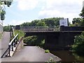
Lambhill Bridge
spans the Forth & Clyde Canal.
Image: © william craig
Taken: 26 Mar 2005
0.08 miles
9
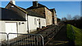
Lambhill Stables
Category B listed http://portal.historicenvironment.scot/designation/LB33739 former stables beside the Forth and Clyde Canal. Originally one of several similar stables for the horses for the horse-drawn boats along the Forth and Clyde Canal, the buildings were derelict for many years. Since 2011 they have been the centre for a local community hub, offering a wide range of activities for the local community, including a cafe and bike hub.
Seen from Lambhill Bridge.
Image: © Richard Sutcliffe
Taken: 19 Jan 2023
0.08 miles
10
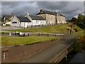
Lambhill Stables
The nineteenth-century stables are described at https://canmore.org.uk/site/44162/glasgow-forth-and-clyde-canal-11-21-25-and-27-canal-bank (at Canmore) as "Horse Barracks", one of several stable blocks that provided fresh horses for drawing fast passenger boats along the canal. The Canmore page also includes some older photographs of the buildings.
The buildings had become derelict, and some of them were roofless by 2002, but they were refurbished, opening in 2011; amongst other things, they provide educational resources for the local community.
Image: © Lairich Rig
Taken: 1 Oct 2012
0.08 miles