IMAGES TAKEN NEAR TO
Tresta Road, GLASGOW, G23 5DE
Introduction
This page details the photographs taken nearby to Tresta Road, G23 5DE by members of the Geograph project.
The Geograph project started in 2005 with the aim of publishing, organising and preserving representative images for every square kilometre of Great Britain, Ireland and the Isle of Man.

There are currently over 7.5m images from over14,400 individuals and you can help contribute to the project by visiting https://www.geograph.org.uk
Image Map
Images are licensed for reuse under creativecommons.org/licenses/by-sa/2.0
Notes
- Clicking on the map will re-center to the selected point.
- The higher the marker number, the further away the image location is from the centre of the postcode.
Image Listing (14 Images Found)
Images are licensed for reuse under creativecommons.org/licenses/by-sa/2.0
Image
Details
Distance
1
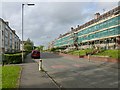
Skirsa Street
The refurbishment shown taking place here is intended to make the homes more energy-efficient.
The streets in this area are named after places in the Shetlands.
Image: © Lairich Rig
Taken: 1 Oct 2012
0.05 miles
2
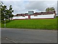
Cadder Community Education Centre
When this picture was taken, the existing community centre included the building shown here, and the one that is partly visible to its left; however, a new Community Centre and Sports Hall are being planned.
The existing buildings are accessed from Fara Street, and they lie between Skirsa Street (from which the picture was taken) and Tresta Road (on these street-names, see Image).
Image: © Lairich Rig
Taken: 1 Oct 2012
0.10 miles
3
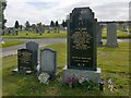
Memorial to Benny Lynch
This is the memorial of the boxer Benny Lynch, "undefeated Flyweight Champion of the World, the first Scotsman to win a world boxing title". It also commemorates his son.
Image: © Lairich Rig
Taken: 1 Oct 2012
0.12 miles
4
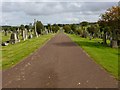
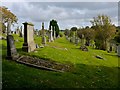
St Kentigern's R.C. Cemetery
This is a view east from near the Image
Image: © Lairich Rig
Taken: 1 Oct 2012
0.14 miles
5
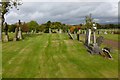
St Kentigern's R.C. Cemetery
The picture was taken near the south-western corner of the cemetery.
Image: © Lairich Rig
Taken: 1 Oct 2012
0.17 miles
6
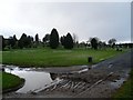
St Kentigern's R.C. Cemetery
This is a view north from the path shown in Image
Image: © Lairich Rig
Taken: 1 Oct 2012
0.17 miles
7
St Kentigern's Cemetery
One of the many names of the Necropolis in the North of Glasgow.
Image: © Stephen Sweeney
Taken: 20 Jan 2009
0.17 miles
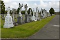
8
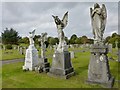
Statues in St Kentigern's R.C. Cemetery
Memorial statuary commemorating Italian families is clustered on the north side of one of the main pathways through the cemetery. These are just part of a larger group: Image
Image: © Lairich Rig
Taken: 1 Oct 2012
0.17 miles
9
Statues in St Kentigern's R.C. Cemetery
Italian families are commemorated by the statues clustered here along the northern side of one of the main footpaths in the cemetery (it was perhaps originally also a driveway for carriages). Only the nearest few memorials (Image) are located within the same grid square as the photographer's position.
Image: © Lairich Rig
Taken: 1 Oct 2012
0.17 miles
10
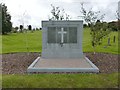
War Veterans' Memorial
"To the honoured memory of those sailors and soldiers who gave their lives for their country during the Great War 1914-1918 who lie buried in this cemetery and are not commemorated elsewhere."
There are 134 scattered First World War burials in the cemetery, but this screen wall commemorates those whose graves are not marked by headstones.
Image: © Lairich Rig
Taken: 1 Oct 2012
0.18 miles