IMAGES TAKEN NEAR TO
Herma Street, GLASGOW, G23 5AN
Introduction
This page details the photographs taken nearby to Herma Street, G23 5AN by members of the Geograph project.
The Geograph project started in 2005 with the aim of publishing, organising and preserving representative images for every square kilometre of Great Britain, Ireland and the Isle of Man.

There are currently over 7.5m images from over14,400 individuals and you can help contribute to the project by visiting https://www.geograph.org.uk
Image Map
Images are licensed for reuse under creativecommons.org/licenses/by-sa/2.0
Notes
- Clicking on the map will re-center to the selected point.
- The higher the marker number, the further away the image location is from the centre of the postcode.
Image Listing (24 Images Found)
Images are licensed for reuse under creativecommons.org/licenses/by-sa/2.0
Image
Details
Distance
1
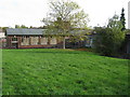
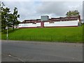
Cadder Primary School
On Herma Street, Glasgow.
Image: © G Laird
Taken: 23 Oct 2010
0.03 miles
2
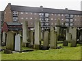
Maryhill Cemetery, Tresta Road, Glasgow
A curious juxtaposition of old graveyard, this part apparently being the Jewish section, and late 20th century Scottish tenement flats.
Image: © Mike Pennington
Taken: 24 Dec 2008
0.12 miles
3
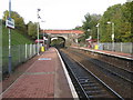
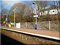
Gilshochill Railway Station
The station between Possilpark & Parkhouse Station and Summerston Station on the Glasgow Queen Street to Anniesland railway line.
Image: © G Laird
Taken: 23 Oct 2010
0.12 miles
4
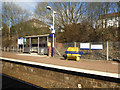
Gilsochill railway station
Pronounced "Gilshyhill", the station is on the Maryhill Line in the north of Glasgow.
Image: © Thomas Nugent
Taken: 19 Mar 2016
0.14 miles
5
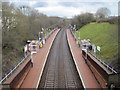
Gilshochill railway station, Glasgow
Opened in 1993 by British Rail on the line from Glasgow Queen Street (High Level) to Anniesland. View south east towards Possilpark and Queen Street, this is also the connection from Glasgow to the West Highland line.
Image: © Nigel Thompson
Taken: 15 Mar 2013
0.14 miles
6
Gilsochill railway station
Pronounced "Gilshyhill", the station is on the Maryhill Line in the north of Glasgow.
Image: © Thomas Nugent
Taken: 19 Mar 2016
0.14 miles
7
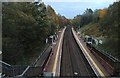
Gilsochill railway station
The station is between Summerston station and Possilpark & Parkhouse station on the Anniesland line from Queen Street.
Image: © Thomas Nugent
Taken: 31 Oct 2023
0.15 miles
8
Cadder Community Education Centre
When this picture was taken, the existing community centre included the building shown here, and the one that is partly visible to its left; however, a new Community Centre and Sports Hall are being planned.
The existing buildings are accessed from Fara Street, and they lie between Skirsa Street (from which the picture was taken) and Tresta Road (on these street-names, see Image).
Image: © Lairich Rig
Taken: 1 Oct 2012
0.16 miles
9
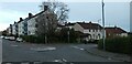
Tresta Road
Herma Street is to the right. Near Gilsochill railway station.
Image: © Thomas Nugent
Taken: 31 Oct 2023
0.16 miles
10
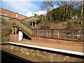
Gilsochill railway station
Pronounced "Gilshyhill", the station is on the Maryhill Line in the north of Glasgow. The steps lead up from Platform 1 to Cadder Road.
Image: © Thomas Nugent
Taken: 19 Mar 2016
0.16 miles