IMAGES TAKEN NEAR TO
Shieldaig Road, GLASGOW, G22 7PN
Introduction
This page details the photographs taken nearby to Shieldaig Road, G22 7PN by members of the Geograph project.
The Geograph project started in 2005 with the aim of publishing, organising and preserving representative images for every square kilometre of Great Britain, Ireland and the Isle of Man.

There are currently over 7.5m images from over14,400 individuals and you can help contribute to the project by visiting https://www.geograph.org.uk
Image Map
Images are licensed for reuse under creativecommons.org/licenses/by-sa/2.0
Notes
- Clicking on the map will re-center to the selected point.
- The higher the marker number, the further away the image location is from the centre of the postcode.
Image Listing (20 Images Found)
Images are licensed for reuse under creativecommons.org/licenses/by-sa/2.0
Image
Details
Distance
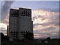
2
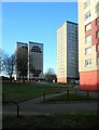
Tower blocks
Three tower blocks at Castlebay Drive.
Image: © Richard Sutcliffe
Taken: 19 Jan 2023
0.10 miles
3
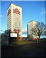
Welcome to Castlebay Drive
Two of the three tower blocks at Castlebay Drive, on the edge of Milton.
Image: © Richard Sutcliffe
Taken: 19 Jan 2023
0.14 miles
4
123 Castlebay Drive
A tower block on the edge of Milton.
Image: © Richard Sutcliffe
Taken: 19 Jan 2023
0.15 miles
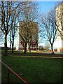
6
Castlebay Drive
Tower blocks on the northern fringe of Milton
Image: © Chris Upson
Taken: 6 Sep 2005
0.16 miles
7
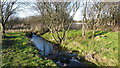
Possil Loch outflow
Excess water from Possil Loch flows along a narrow channel into the adjacent Forth and Clyde Canal.
Image: © Richard Sutcliffe
Taken: 12 Jan 2012
0.16 miles
8
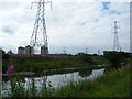
Pylon beside Forth & Clyde Canal
Pylon and power lines next to the canal beside Possil Marsh.
Image: © Richard Sutcliffe
Taken: 29 May 2012
0.16 miles
9
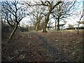
Semi-open woodland
Beside Castlebay Street.
Image: © Richard Sutcliffe
Taken: 19 Jan 2023
0.16 miles
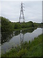
10
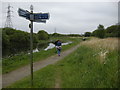
Towpath, Forth & Clyde Canal
The towpath of the Forth and Clyde Canal beside Possil Marsh.
Image: © Richard Sutcliffe
Taken: 29 May 2012
0.18 miles