IMAGES TAKEN NEAR TO
Ashgill Road, GLASGOW, G22 7HH
Introduction
This page details the photographs taken nearby to Ashgill Road, G22 7HH by members of the Geograph project.
The Geograph project started in 2005 with the aim of publishing, organising and preserving representative images for every square kilometre of Great Britain, Ireland and the Isle of Man.

There are currently over 7.5m images from over14,400 individuals and you can help contribute to the project by visiting https://www.geograph.org.uk
Image Map
Images are licensed for reuse under creativecommons.org/licenses/by-sa/2.0
Notes
- Clicking on the map will re-center to the selected point.
- The higher the marker number, the further away the image location is from the centre of the postcode.
Image Listing (18 Images Found)
Images are licensed for reuse under creativecommons.org/licenses/by-sa/2.0
Image
Details
Distance
1
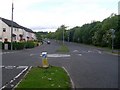
Ashgill Road mini roundabout
At the junction with Shillay Street.
Image: © Stephen Sweeney
Taken: 27 May 2009
0.04 miles
2
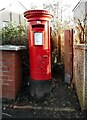
George VI pillar box
On the corner of Torogay Street and Shillay Street, set in between two walls. It is postbox number G22 1171D
Image: © Richard Sutcliffe
Taken: 19 Jan 2023
0.04 miles
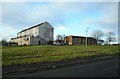
3
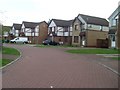
John Marshall Drive
Street in Colston, east of Ashgill Road.
Image: © Stephen Sweeney
Taken: 27 May 2009
0.15 miles
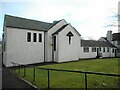
4
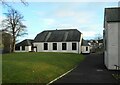
Church hall, St Augustine's
Hall for the Roman Catholic church on Ronaldsay Street.
Image: © Richard Sutcliffe
Taken: 19 Jan 2023
0.16 miles
5
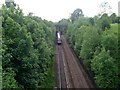
Railway line in Bishopbriggs
Train heading to Glasgow Queen Street, probably coming in from Edinburgh.
Image: © Stephen Sweeney
Taken: 27 May 2009
0.16 miles
6
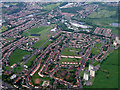
Milton from the air
Milton, on the north side of Glasgow, with the Scaraway Street towerblocks in the lower right and the edge of Possil Loch towards the top right. The Forth & Clyde Canal can also be seen.
Image: © Thomas Nugent
Taken: 9 Jun 2012
0.17 miles
7
St Augustine's Church
Roman Catholic church on Ronaldsay Street. It, together with the adjoining presbytery Image date from 1954-56 and are Category B listed http://portal.historicenvironment.scot/designation/LB33736.
Image: © Richard Sutcliffe
Taken: 19 Jan 2023
0.18 miles
8
Shops, Liddesdale Square
Side view of shops with flats above, seen from beside St Augustine's Church.
Image: © Richard Sutcliffe
Taken: 19 Jan 2023
0.18 miles
9
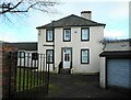
Presbytery, St Augustine's Church
The church and presbytery date from 1954-6 and are Category B listed http://portal.historicenvironment.scot/designation/LB33736.
Image: © Richard Sutcliffe
Taken: 19 Jan 2023
0.20 miles
10

Shops in Milton
At Liddesdale Square.
Image: © Stephen Sweeney
Taken: 27 May 2009
0.20 miles