IMAGES TAKEN NEAR TO
Broadholm Street, GLASGOW, G22 6SP
Introduction
This page details the photographs taken nearby to Broadholm Street, G22 6SP by members of the Geograph project.
The Geograph project started in 2005 with the aim of publishing, organising and preserving representative images for every square kilometre of Great Britain, Ireland and the Isle of Man.

There are currently over 7.5m images from over14,400 individuals and you can help contribute to the project by visiting https://www.geograph.org.uk
Image Map
Images are licensed for reuse under creativecommons.org/licenses/by-sa/2.0
Notes
- Clicking on the map will re-center to the selected point.
- The higher the marker number, the further away the image location is from the centre of the postcode.
Image Listing (28 Images Found)
Images are licensed for reuse under creativecommons.org/licenses/by-sa/2.0
Image
Details
Distance
1
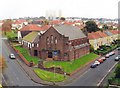
Trinity Possil and Henry Drummond Church of Scotland
Taken from flats opposite church building
Image: © Isabel Whyte
Taken: Unknown
0.06 miles
2
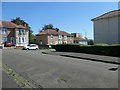
Gadloch Street from Coltmuir Street, Glasgow
This estate was built before 1933.
Image: © Christine Johnstone
Taken: 26 Jun 2019
0.08 miles
3
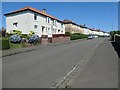
Broadholm Street, off Balmore Road, Glasgow
Built before 1933.
Image: © Christine Johnstone
Taken: 26 Jun 2019
0.14 miles
4
Possilpark and Parkhouse Station
The modern station in Possil, just down the road from the old station.
Image: © Stephen Sweeney
Taken: 20 Jan 2009
0.16 miles
5
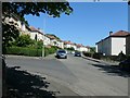
The north side of Coltmuir Street, Glasgow
Running east from Bracken Street. This estate was built before 1933.
Image: © Christine Johnstone
Taken: 26 Jun 2019
0.17 miles
6
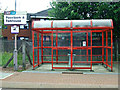
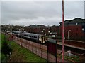
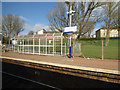
Possilpark & Parkhouse railway station
On the Maryhill Line, between Gilshochill and Ashfield stations. Note the old livery SPT orange coloured shelter.
Image: © Thomas Nugent
Taken: 10 Aug 2013
0.17 miles
7
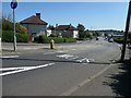
Ashfield Street, Glasgow, looking south
There is a 66 metre spot height at the crossroads [junction with Glenhead Street].
Image: © Christine Johnstone
Taken: 26 Jun 2019
0.17 miles
8
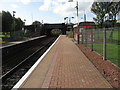
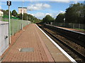
Possilpark & Parkhouse railway station
View from platform 1 at Possilpark & Parkhouse railway station, looking towards Anniesland via Maryhill.
Image: © Andrew Reid
Taken: 19 Sep 2011
0.18 miles
9
Possilpark & Parkhouse railway station
View from platform 1 at Possilpark & Parkhouse railway station, looking towards Glasgow Queen Street.
Image: © Andrew Reid
Taken: 19 Sep 2011
0.18 miles
10
Possilpark and Parkhouse railway station
The station is on the Maryhill Line in the north of Glasgow.
Image: © Thomas Nugent
Taken: 19 Mar 2016
0.18 miles