IMAGES TAKEN NEAR TO
Hawthorn Street, GLASGOW, G22 6RG
Introduction
This page details the photographs taken nearby to Hawthorn Street, G22 6RG by members of the Geograph project.
The Geograph project started in 2005 with the aim of publishing, organising and preserving representative images for every square kilometre of Great Britain, Ireland and the Isle of Man.

There are currently over 7.5m images from over14,400 individuals and you can help contribute to the project by visiting https://www.geograph.org.uk
Image Map (Loading...)


Getting Data...Please wait
Leaflet Map data © OpenStreetMap
Images are licensed for reuse under creativecommons.org/licenses/by-sa/2.0
Notes
- Clicking on the map will re-center to the selected point.
- The higher the marker number, the further away the image location is from the centre of the postcode.
Image Listing (22 Images Found)
Images are licensed for reuse under creativecommons.org/licenses/by-sa/2.0
Image
Details
Distance
1
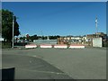
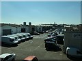
Traffic management, Ashfield Street, Possil, Glasgow
No through route to Hawthorn Street. The fenced area is a former tram depot.
Image: © Christine Johnstone
Taken: 26 Jun 2019
0.05 miles
2
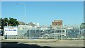
Mission in Possil, Glasgow
Allied Vehicles has purchased this site, which was once the tram depot.
Image: © Christine Johnstone
Taken: 26 Jun 2019
0.07 miles
3
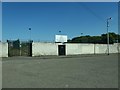
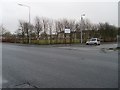
Keppoch Park, Possil, Glasgow
On Ashfield Street and home to Glasgow Perthshire F.C.
Image: © Christine Johnstone
Taken: 26 Jun 2019
0.08 miles
4
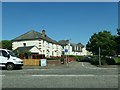
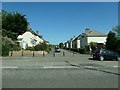
Hawthorn Quadrant, from Ashfield Street, Glasgow
Part of a small estate where the roads are named after trees - hawthorn, walnut, spruce, cypress and chestnut.
Image: © Christine Johnstone
Taken: 26 Jun 2019
0.09 miles
5
Denmark Street industrial centre, Glasgow
Between Possil Park trading centre and Ashfield Road. In the 1930s this was part of the Clydesdale Ironworks.
Image: © Christine Johnstone
Taken: 26 Jun 2019
0.09 miles
6
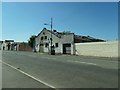
Hawthorn Street at Saracen Street
In Possil Park.
Image: © Stephen Sweeney
Taken: 20 Jan 2009
0.12 miles
7
Walnut Street, from Ashfield Street, Glasgow
Chestnut, Cypress, Spruce and Hawthorn are all close by.
Image: © Christine Johnstone
Taken: 26 Jun 2019
0.13 miles
8
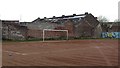
Blaes pitch, Ashfield Street
Football pitch with derelict industrial surrounds. One touchline is a wall with lots of self improvement mission statements which would be familiar to any one visiting a modern school.
Image: © Richard Webb
Taken: 9 May 2012
0.15 miles
9
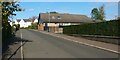
Spruce Street
The photograph was taken from the point where this street leaves the main road (Hawthorn Street), and is a view towards the point where it meets Walnut Road.
The prominent building on the right is the clubhouse of Hawthorn Bowling Club; the bowling green itself is behind the hedge.
Image: © Lairich Rig
Taken: 11 Oct 2010
0.15 miles
10
Derelict building, Bardowie Street, Possilpark, Glasgow
In the 1930s, the site of Keppoch Ironworks.
Image: © Christine Johnstone
Taken: 26 Jun 2019
0.17 miles