IMAGES TAKEN NEAR TO
Balmore Road, GLASGOW, G22 6NT
Introduction
This page details the photographs taken nearby to Balmore Road, G22 6NT by members of the Geograph project.
The Geograph project started in 2005 with the aim of publishing, organising and preserving representative images for every square kilometre of Great Britain, Ireland and the Isle of Man.

There are currently over 7.5m images from over14,400 individuals and you can help contribute to the project by visiting https://www.geograph.org.uk
Image Map
Images are licensed for reuse under creativecommons.org/licenses/by-sa/2.0
Notes
- Clicking on the map will re-center to the selected point.
- The higher the marker number, the further away the image location is from the centre of the postcode.
Image Listing (36 Images Found)
Images are licensed for reuse under creativecommons.org/licenses/by-sa/2.0
Image
Details
Distance
1
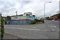
The Glasgow offices of Scottish Water
When this picture was taken, these were the Glasgow Offices of Scottish Water. However, the company is to relocate their Glasgow operations to Image, at Stepps, by 2013.
Image: © Lairich Rig
Taken: 1 Oct 2012
0.05 miles
2
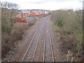
Possilpark railway station (site), Glasgow
Opened in 1885 on this North British Railway line from Glasgow Queen Street (High Level) towards Anniesland and the West Highland line, this station closed to passengers in 1917 but remained open for workmen only until 1964. It was demolished following closure.
View west towards Gilshochill and Anniesland. A new station called "Possilpark and Parkhouse" was opened immediately behind the camera position by British Rail in 1993 - see Image
Image: © Nigel Thompson
Taken: 15 Mar 2013
0.07 miles
3
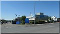
Entrance to Parkhouse Business Park
In the 1930s this area was a farm and allotments.
Image: © Christine Johnstone
Taken: 26 Jun 2019
0.07 miles
4
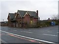
Possil railway station (site), Glasgow
Opened in 1897 as by the Lanarkshire and Dumbartonshire Railway, part of the Caledonian Railway, as the terminus of its passenger service from Dumbarton via Whiteinch, this station closed in 1908. It was reopened in 1934 but closed permanently in 1964.
View north west at the main building, beyond which were steps down to platform level. It doesn't appear to be much longer for this world.
Image: © Nigel Thompson
Taken: 21 Feb 2019
0.08 miles
5
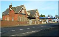
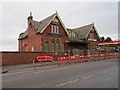
Former Possil Station building
A Category C listed building, built facing onto Balmore Road, above the railway lines which formerly ran east to west under the road. Built in 1897 for the Lanarkshire and Dumbarton Railway, the station finally closed in 1964. Now in very poor condition, it is listed on the Buildings at Risk Register [http://www.buildingsatrisk.org.uk/details/904492].
Image: © Richard Sutcliffe
Taken: 2 Mar 2017
0.08 miles
8
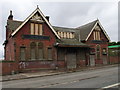
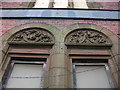
Possil Station
This impressive station building belonged to the Caledonian Railway (the carvings still visible above the arched windows feature the ornate letters 'C', 'R' and the corporate logo). Possil station was on the Caledonian's Hamiltonhill Branch, connecting Maryhill to Robroyston.
Image: © Raymond Okonski
Taken: 31 Oct 2007
0.10 miles
10
![Temporary footpath, Balmore Road [A879]](https://s0.geograph.org.uk/geophotos/06/20/58/6205856_85bbe45e_120x120.jpg)
Temporary footpath, Balmore Road [A879]
The east side of the road was closed at the railway bridge near Possilpark and Parkhouse station.
Image: © Christine Johnstone
Taken: 26 Jun 2019
0.11 miles