IMAGES TAKEN NEAR TO
Claddens Street, GLASGOW, G22 6LX
Introduction
This page details the photographs taken nearby to Claddens Street, G22 6LX by members of the Geograph project.
The Geograph project started in 2005 with the aim of publishing, organising and preserving representative images for every square kilometre of Great Britain, Ireland and the Isle of Man.

There are currently over 7.5m images from over14,400 individuals and you can help contribute to the project by visiting https://www.geograph.org.uk
Image Map
Images are licensed for reuse under creativecommons.org/licenses/by-sa/2.0
Notes
- Clicking on the map will re-center to the selected point.
- The higher the marker number, the further away the image location is from the centre of the postcode.
Image Listing (31 Images Found)
Images are licensed for reuse under creativecommons.org/licenses/by-sa/2.0
Image
Details
Distance
1
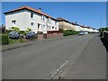
The north side of Coltmuir Street, Glasgow
Running east from Bracken Street. This estate was built before 1933.
Image: © Christine Johnstone
Taken: 26 Jun 2019
0.04 miles
2
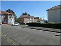
Broadholm Street, off Balmore Road, Glasgow
Built before 1933.
Image: © Christine Johnstone
Taken: 26 Jun 2019
0.08 miles
3
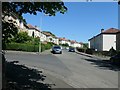
Gadloch Street from Coltmuir Street, Glasgow
This estate was built before 1933.
Image: © Christine Johnstone
Taken: 26 Jun 2019
0.08 miles
4
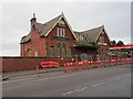
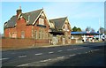
Possil railway station (site), Glasgow
Opened in 1897 as by the Lanarkshire and Dumbartonshire Railway, part of the Caledonian Railway, as the terminus of its passenger service from Dumbarton via Whiteinch, this station closed in 1908. It was reopened in 1934 but closed permanently in 1964.
View north west at the main building, beyond which were steps down to platform level. It doesn't appear to be much longer for this world.
Image: © Nigel Thompson
Taken: 21 Feb 2019
0.12 miles
5
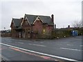
Former Possil Station building
A Category C listed building, built facing onto Balmore Road, above the railway lines which formerly ran east to west under the road. Built in 1897 for the Lanarkshire and Dumbarton Railway, the station finally closed in 1964. Now in very poor condition, it is listed on the Buildings at Risk Register [http://www.buildingsatrisk.org.uk/details/904492].
Image: © Richard Sutcliffe
Taken: 2 Mar 2017
0.12 miles
6
Possilpark and Parkhouse Station
The modern station in Possil, just down the road from the old station.
Image: © Stephen Sweeney
Taken: 20 Jan 2009
0.13 miles
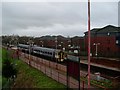
9
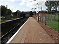
Possilpark & Parkhouse railway station
View from platform 1 at Possilpark & Parkhouse railway station, looking towards Anniesland via Maryhill.
Image: © Andrew Reid
Taken: 19 Sep 2011
0.13 miles
10
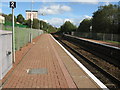
Possilpark & Parkhouse railway station
View from platform 1 at Possilpark & Parkhouse railway station, looking towards Glasgow Queen Street.
Image: © Andrew Reid
Taken: 19 Sep 2011
0.13 miles