IMAGES TAKEN NEAR TO
Mireton Street, GLASGOW, G22 6JR
Introduction
This page details the photographs taken nearby to Mireton Street, G22 6JR by members of the Geograph project.
The Geograph project started in 2005 with the aim of publishing, organising and preserving representative images for every square kilometre of Great Britain, Ireland and the Isle of Man.

There are currently over 7.5m images from over14,400 individuals and you can help contribute to the project by visiting https://www.geograph.org.uk
Image Map
Images are licensed for reuse under creativecommons.org/licenses/by-sa/2.0
Notes
- Clicking on the map will re-center to the selected point.
- The higher the marker number, the further away the image location is from the centre of the postcode.
Image Listing (23 Images Found)
Images are licensed for reuse under creativecommons.org/licenses/by-sa/2.0
Image
Details
Distance
1
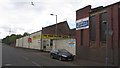
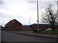
Stronend Road
Industrial buildings on the northside of Stronend Road.
Image: © Richard Webb
Taken: 9 May 2012
0.07 miles
2
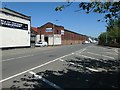
Crownall Equipment, Stronend Street, Glasgow
The trade counter at the western end of the building.
Image: © Christine Johnstone
Taken: 26 Jun 2019
0.09 miles
3
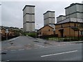
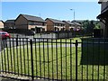
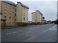
Westercommon Road flats and new housing estate in Possil Park
From Stronend Street.
Image: © Stephen Sweeney
Taken: 20 Jan 2009
0.09 miles
4
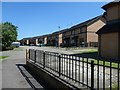
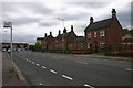
Houses on the south side of Stronend Street, Glasgow
Replacing an earlier housing estate in Possil Park.
Image: © Christine Johnstone
Taken: 26 Jun 2019
0.09 miles
5
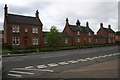
Houses in Balglass Street, Glasgow
On the south side of Panmure and Stronend Streets.
Image: © Christine Johnstone
Taken: 26 Jun 2019
0.12 miles
6
Junction of Bilsland Drive and Balmore Road
Image: © Elliott Simpson
Taken: 27 Jan 2011
0.13 miles
8
Houses, Bilsland Drive
Very distinctive red sandstone buildings on the southern side of Bilsland Drive.
Image: © Richard Sutcliffe
Taken: 14 Sep 2015
0.13 miles
9
Modern flats on Panmure Road
In Possil Park.
Image: © Stephen Sweeney
Taken: 20 Jan 2009
0.15 miles
10
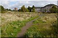
Open space, Ruchill
The picture was taken from Image; this site lies between that road and Balmore Road.
The space is open because this was the course of a railway line, namely, the LMS Hamiltonhill Branch railway line (LMS: London, Midland and Scottish Railway). The line ran SW-NE here; on the far side of Balmore Road, a car park is also oriented along the former course of the line.
Image: © Lairich Rig
Taken: 1 Oct 2012
0.16 miles