IMAGES TAKEN NEAR TO
Carron Street, GLASGOW, G22 6BE
Introduction
This page details the photographs taken nearby to Carron Street, G22 6BE by members of the Geograph project.
The Geograph project started in 2005 with the aim of publishing, organising and preserving representative images for every square kilometre of Great Britain, Ireland and the Isle of Man.

There are currently over 7.5m images from over14,400 individuals and you can help contribute to the project by visiting https://www.geograph.org.uk
Image Map
Images are licensed for reuse under creativecommons.org/licenses/by-sa/2.0
Notes
- Clicking on the map will re-center to the selected point.
- The higher the marker number, the further away the image location is from the centre of the postcode.
Image Listing (36 Images Found)
Images are licensed for reuse under creativecommons.org/licenses/by-sa/2.0
Image
Details
Distance
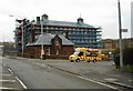
1
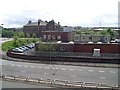
Springburn Police Station
From a path across Springburn Road.
Image: © Stephen Sweeney
Taken: 27 May 2009
0.02 miles
2

The Salvation Army, Springburn
At the junction of Fernbank Street and Hawthorn Street.
Image: © Richard Sutcliffe
Taken: 8 Mar 2017
0.05 miles
3
The Salvation Army, Springburn
On Hawthorn Street.
Image: © Richard Sutcliffe
Taken: 8 Mar 2017
0.05 miles
4
Springburn Road (A803)
Looking North from the bridge where Hawthorn Street crosses Springburn Road.
Image: © G Laird
Taken: 14 Mar 2009
0.05 miles
5
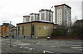
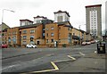
Police Office, 755 Hawthorn Street
The blocks of flats face onto Lenzie Terrace.
Image: © Richard Sutcliffe
Taken: 8 Mar 2017
0.06 miles
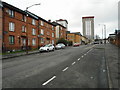
6
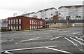
Flats on Hawthorn Street
The tower blocks behind are located between Carbisdale Street and Carron Street.
Image: © Richard Sutcliffe
Taken: 8 Mar 2017
0.06 miles
8
Fernbank Street
Looking towards Hawthorn Street.
Image: © Richard Sutcliffe
Taken: 8 Mar 2017
0.08 miles
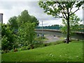
9
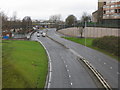
Lenzie Terrace
The photograph was taken from Hawthorn Street, not far west of the point at which it crosses above Springburn Road. It is Springburn Road that appears in this view.
The nearest of the buildings is also shown in Image
Image: © Lairich Rig
Taken: 11 Oct 2010
0.08 miles
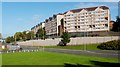
10
Elmvale Primary School and Janitor's Lodge
The Category B listed school is currently covered in scaffolding for renovation work.
Image: © Richard Sutcliffe
Taken: 8 Mar 2017
0.08 miles