IMAGES TAKEN NEAR TO
Carron Crescent, GLASGOW, G22 6AX
Introduction
This page details the photographs taken nearby to Carron Crescent, G22 6AX by members of the Geograph project.
The Geograph project started in 2005 with the aim of publishing, organising and preserving representative images for every square kilometre of Great Britain, Ireland and the Isle of Man.

There are currently over 7.5m images from over14,400 individuals and you can help contribute to the project by visiting https://www.geograph.org.uk
Image Map
Images are licensed for reuse under creativecommons.org/licenses/by-sa/2.0
Notes
- Clicking on the map will re-center to the selected point.
- The higher the marker number, the further away the image location is from the centre of the postcode.
Image Listing (55 Images Found)
Images are licensed for reuse under creativecommons.org/licenses/by-sa/2.0
Image
Details
Distance
1

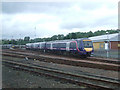
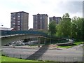
Eastfield View
Looking towards a set of tower blocks from a train passing the former Eastfield depot. Seen shortly after emerging from the Cowlairs Tunnel, these blocks always catch the eye.
Image: © Mary and Angus Hogg
Taken: 23 Mar 2015
0.06 miles
2
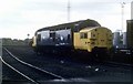
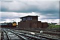
On the shed
37112 at the south end of Eastfield shed One of the regular locos used on the West Highland railway at this time.
Image: © roger geach
Taken: Unknown
0.07 miles
3
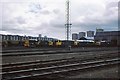
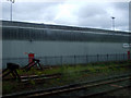
Eastfield Railway Depot
At Cowlairs North. Click on this http://www.kirwindesign.co.uk/Eastfield_real.htm for the history of the depot.
Image: © Thomas Nugent
Taken: 11 Jul 2010
0.10 miles
4
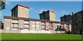
Housing on Carron Street
The high flats in the background are on Carbisdale Street, in the Fernbank area of Springburn (they also appear in Image), but the buildings in front of them are on Carron Street.
The building at the right-hand edge of the photograph is on Horne Street.
For a more wintry view, see Image
Image: © Lairich Rig
Taken: 11 Oct 2010
0.10 miles
5
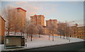
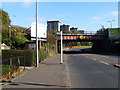
High rise from Hawthorn Street
A set of high rise blocks of flats viewed from Hawthorn Street. Compare with Image taken in more clement weather.
Image: © Mark Nightingale
Taken: 22 Dec 2010
0.11 miles
6
Springburn flats
Just north of Hawthorn Street.
Image: © Stephen Sweeney
Taken: 27 May 2009
0.11 miles
8
Railway bridge over Hawthorn Street
The same bridge is shown, from the other side, in Image (the bus stop sign that appears in the foreground of my photo can also be seen there); see that item for further details.
The four high flats visible in the background of the present photograph stand on Carbisdale Street, in the Fernbank area of Springburn.
Image: © Lairich Rig
Taken: 11 Oct 2010
0.13 miles
9
Eastfield depot and surrounding council flats 1978
The old Eastfield diesel depot in late 1978 (Nov/Dec) with a variety of locomotives on shed.
Image: © Peter Whatley
Taken: Unknown
0.13 miles
10
Shed and buffers
At Eastfield Depot. Click on this http://www.kirwindesign.co.uk/Eastfield_real.htm for more information about the depot.
Image: © Thomas Nugent
Taken: 11 Jul 2010
0.13 miles