IMAGES TAKEN NEAR TO
Caldarvan Street, GLASGOW, G22 5RG
Introduction
This page details the photographs taken nearby to Caldarvan Street, G22 5RG by members of the Geograph project.
The Geograph project started in 2005 with the aim of publishing, organising and preserving representative images for every square kilometre of Great Britain, Ireland and the Isle of Man.

There are currently over 7.5m images from over14,400 individuals and you can help contribute to the project by visiting https://www.geograph.org.uk
Image Map
Images are licensed for reuse under creativecommons.org/licenses/by-sa/2.0
Notes
- Clicking on the map will re-center to the selected point.
- The higher the marker number, the further away the image location is from the centre of the postcode.
Image Listing (128 Images Found)
Images are licensed for reuse under creativecommons.org/licenses/by-sa/2.0
Image
Details
Distance
1
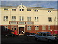
Partick Thistle Football Ground
aka Firhill Park, home of the Jags
Image: © Chris Upson
Taken: 6 Sep 2005
0.00 miles
2
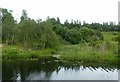
Arm off the Forth and Clyde Canal Glasgow Branch
Old maps show that this served a claypit where the ground rises at the back, and also the Hamiltonhill Slip, a boatbuilding yard just on the right hand side of the entrance to the arm.
Image: © Alan Murray-Rust
Taken: 25 Jun 2019
0.14 miles
3
Forth and Clyde Canal
The entrance to an overgrown old dock or basin near Firhill.
Image: © Thomas Nugent
Taken: 13 Feb 2009
0.15 miles
4
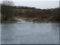
Forth and Clyde Canal
Looking along a frozen stretch of the canal towards Firhill from Applecross Street basin.
Image: © Thomas Nugent
Taken: 13 Feb 2009
0.15 miles
5
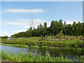
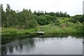
![Forth and Clyde Canal [13]](https://s1.geograph.org.uk/geophotos/06/24/83/6248389_8f935791_120x120.jpg)
Forth and Clyde Canal [13]
A heron on the bank of the canal. The far side of the canal is Hamilton Hill Claypits Local Nature Reserve. Details are at: https://www.scottishcanals.co.uk/news/new-pathway-unlocks-glasgows-secret-nature-reserve/
The Forth and Clyde Canal was completed in 1790 and it provided a route for vessels between the Firth of Forth and the Firth of Clyde at the narrowest part (35 miles, 56km) of the Scottish Lowlands. Closed in 1963, the canal became semi-derelict. Millennium funds were used to regenerate the canal. The Glasgow Branch of the canal is a Scheduled Monument with details at: http://portal.historicenvironment.scot/designation/SM6771
Image: © Michael Dibb
Taken: 25 Jun 2019
0.16 miles
6
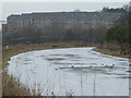
Claypits Nature Reserve
Viewed from across the canal; the reserve was closed to visitors at this time for construction works.
Image: © Stephen Craven
Taken: 25 Jun 2019
0.16 miles
7
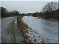
Forth and Clyde Canal
Looking towards Firhill from Applecross Street. the flats are on Murano Street.
Image: © Thomas Nugent
Taken: 13 Feb 2009
0.16 miles
8
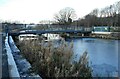
New bridge over the canal
Garscube Bridge is a new footbridge over the Forth and Clyde Canal to give access to the Claypits Nature Reserve on the north bank of the canal. There is ice on the surface of the canal following recent cold weather.
Image: © Richard Sutcliffe
Taken: 9 Dec 2022
0.16 miles
9
New bridge over the canal
Garscube Bridge is a new footbridge over the Forth and Clyde Canal to give access to the Claypits Nature Reserve on the north bank of the canal. There is ice on the surface of the canal following recent cold weather.
Image: © Richard Sutcliffe
Taken: 9 Dec 2022
0.16 miles
10
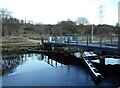
Overgrown canal basin
This canal basin on the Glassgow Branch of the Forth and Clyde Canal used to serve a quarry which produced clay that was used to line the canal itself. It was later a small boatbuilding yard.
The grassland and woodland beside it are part of Hamiltonhill Claypits Local Nature Reserve.
Image: © Richard Sutcliffe
Taken: 25 Jun 2019
0.17 miles