IMAGES TAKEN NEAR TO
Ellesmere Street, GLASGOW, G22 5QT
Introduction
This page details the photographs taken nearby to Ellesmere Street, G22 5QT by members of the Geograph project.
The Geograph project started in 2005 with the aim of publishing, organising and preserving representative images for every square kilometre of Great Britain, Ireland and the Isle of Man.

There are currently over 7.5m images from over14,400 individuals and you can help contribute to the project by visiting https://www.geograph.org.uk
Image Map
Images are licensed for reuse under creativecommons.org/licenses/by-sa/2.0
Notes
- Clicking on the map will re-center to the selected point.
- The higher the marker number, the further away the image location is from the centre of the postcode.
Image Listing (144 Images Found)
Images are licensed for reuse under creativecommons.org/licenses/by-sa/2.0
Image
Details
Distance
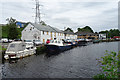
1
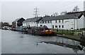
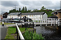
Applecross Street basin
A variety of craft at the Scottish HQ of British Waterways.
Image: © Thomas Nugent
Taken: 13 Feb 2009
0.04 miles
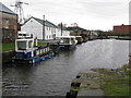
2
British Waterways Scottish HQ
At Applecross Street basin on the Glasgow branch of the Forth & Clyde canal.
Image: © Thomas Nugent
Taken: 13 Feb 2009
0.05 miles
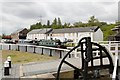
3
Applecross Street Basin
Part of the Glasgow Branch of the Forth and Clyde Canal, which was built between 1768 and 1790.
The building just beyond the long white building is the British Waterways Scotland H.Q.
Image: © G Laird
Taken: 14 Mar 2009
0.06 miles
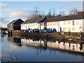
4
Basin on the Forth & Clyde Canal
The central building is the headquarters of Scottish Canals who administer the five Scottish canals - the Caledonian, Crinan, Forth & Clyde, Union and Monkland canals (this last one now mainly culverted and a source of water for the Forth & Clyde Canal)
Image: © Gordon Brown
Taken: 24 Jul 2017
0.06 miles
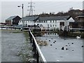
5
Old Basin Works
The buildings of the Old Basin Works are boarded up, perhaps awaiting a new lease of life as a pub or restaurant like so many other canalside buildings.
Image: © Anne Burgess
Taken: 25 Jun 2019
0.06 miles
7
Applecross Street canal basin
More detail on the (listed) buildings seen here, and on the canal, accompanies Image A new bridge is currently being constructed over the canal and the footpath is currently closed north of this point for a couple of weeks; note the distant digger just seen at the far left.
Image: © Alec MacKinnon
Taken: 28 Nov 2019
0.06 miles
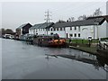
8
Forth and Clyde Canal
Rocks on the surfacs show how thick the ice is at the Applecross Street bridge. The building in the background is the Scottish HQ of British Waterways.
Image: © Thomas Nugent
Taken: 13 Feb 2009
0.06 miles
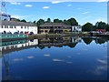
9
Old Basin
The canal branch widens here to form the Old Basin. The Gowanbank Iron Foundry was to the right, and the boarded-up buildings are the Old Basin Works. Beyond them is Canal House, the headquarters of Scottish Canals, and beyond again is Applecross Wharf.
Image: © Anne Burgess
Taken: 25 Jun 2019
0.06 miles
10
![Forth and Clyde Canal [12]](https://s3.geograph.org.uk/geophotos/06/24/49/6244967_d108e465_120x120.jpg)
Forth and Clyde Canal [12]
Formerly known as Hamiltonhill Basin, this was the terminus of the canal until 1790 when the 3 mile link to Port Dundas was completed. The buildings seen across the canal were the canal workshops, built in the late 18th century. They are listed, category B, and there is much detail and history at: http://portal.historicenvironment.scot/designation/LB44020
The Forth and Clyde Canal was completed in 1790 and it provided a route for vessels between the Firth of Forth and the Firth of Clyde at the narrowest part (35 miles, 56km) of the Scottish Lowlands. Closed in 1963, the canal became semi-derelict. Millennium funds were used to regenerate the canal. The Glasgow Branch of the canal is a Scheduled Monument with details at: http://portal.historicenvironment.scot/designation/SM6771
Image: © Michael Dibb
Taken: 25 Jun 2019
0.06 miles