IMAGES TAKEN NEAR TO
Saracen Street, GLASGOW, G22 5LF
Introduction
This page details the photographs taken nearby to Saracen Street, G22 5LF by members of the Geograph project.
The Geograph project started in 2005 with the aim of publishing, organising and preserving representative images for every square kilometre of Great Britain, Ireland and the Isle of Man.

There are currently over 7.5m images from over14,400 individuals and you can help contribute to the project by visiting https://www.geograph.org.uk
Image Map
Images are licensed for reuse under creativecommons.org/licenses/by-sa/2.0
Notes
- Clicking on the map will re-center to the selected point.
- The higher the marker number, the further away the image location is from the centre of the postcode.
Image Listing (14 Images Found)
Images are licensed for reuse under creativecommons.org/licenses/by-sa/2.0
Image
Details
Distance
1
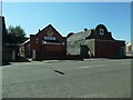
Temple and Masonic lodge, Denmark Street, Glasgow
Particularly convenient for any Hindu Freemasons. The Lodge is Possilpark 1330. Sri Mangala Vinayahar temple was established in 2005 and successfully completed Maha Kumbabhishekam on 17th April 2011.
Image: © Christine Johnstone
Taken: 26 Jun 2019
0.10 miles
2
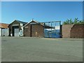
Rowebb Ltd's former premises, Bardowie Street
In the 1930s this site was part of Keppoch Ironworks.
Image: © Christine Johnstone
Taken: 26 Jun 2019
0.11 miles
3
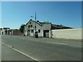
Derelict building, Bardowie Street, Possilpark, Glasgow
In the 1930s, the site of Keppoch Ironworks.
Image: © Christine Johnstone
Taken: 26 Jun 2019
0.13 miles
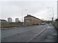
4
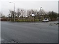
Hawthorn Street at Saracen Street
In Possil Park.
Image: © Stephen Sweeney
Taken: 20 Jan 2009
0.14 miles
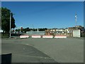
5
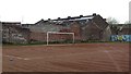
Blaes pitch, Ashfield Street
Football pitch with derelict industrial surrounds. One touchline is a wall with lots of self improvement mission statements which would be familiar to any one visiting a modern school.
Image: © Richard Webb
Taken: 9 May 2012
0.15 miles
6
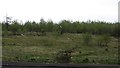
Land awaiting development
Streets revert to birch woods after demolition of buildings. A block off Carbeth Street.
Image: © Richard Webb
Taken: 9 May 2012
0.15 miles
7
Hawthorn Street, Possil Park
Looking west towards the tower of Ruchill Hospital.
Image: © Stephen Sweeney
Taken: 20 Jan 2009
0.15 miles
8
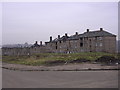
Derelict Housing, Carbeth Street, Possil Park
Glasgow looking like a war zone
Image: © Chris Upson
Taken: 2 Feb 2006
0.18 miles
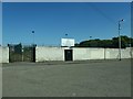
9
Traffic management, Ashfield Street, Possil, Glasgow
No through route to Hawthorn Street. The fenced area is a former tram depot.
Image: © Christine Johnstone
Taken: 26 Jun 2019
0.19 miles
10
Keppoch Park, Possil, Glasgow
On Ashfield Street and home to Glasgow Perthshire F.C.
Image: © Christine Johnstone
Taken: 26 Jun 2019
0.19 miles