IMAGES TAKEN NEAR TO
Finlas Place, GLASGOW, G22 5EX
Introduction
This page details the photographs taken nearby to Finlas Place, G22 5EX by members of the Geograph project.
The Geograph project started in 2005 with the aim of publishing, organising and preserving representative images for every square kilometre of Great Britain, Ireland and the Isle of Man.

There are currently over 7.5m images from over14,400 individuals and you can help contribute to the project by visiting https://www.geograph.org.uk
Image Map
Images are licensed for reuse under creativecommons.org/licenses/by-sa/2.0
Notes
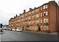
- Clicking on the map will re-center to the selected point.
- The higher the marker number, the further away the image location is from the centre of the postcode.
Image Listing (31 Images Found)
Images are licensed for reuse under creativecommons.org/licenses/by-sa/2.0
Image
Details
Distance
1
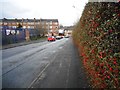
Carlisle Street
A good crop of berries are still on the hedge, despite it being the beginning of March.
Image: © Richard Sutcliffe
Taken: 2 Mar 2017
0.03 miles
3
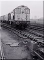
Class 20 at Cowlairs
Unidentified British Rail Class 20 locomotive with train at Cowlairs.
Image: © Richard Sutcliffe
Taken: Unknown
0.06 miles
5

Railway Bridge, Hawthorn Street
The bridge is situated at Cowlairs West Junction, where the railway lines that cross it diverge to north, west, south and south east.
Image: © Richard Sutcliffe
Taken: 2 Mar 2017
0.07 miles
6
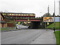
Railway Bridge over Hawthorn Street
The bridge carries the railway line north from Glasgow Queen Street just before it splits at the junction near Springburn.
Image: © G Laird
Taken: 14 Mar 2009
0.07 miles
7
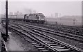
Class 40 at Cowlairs
Unidentified British Rail Class 40 locomotive heading a passenger train from Glasgow Queen Street Station.
Image: © Richard Sutcliffe
Taken: Unknown
0.07 miles
8
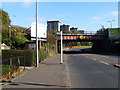
Railway bridge over Hawthorn Street
The same bridge is shown, from the other side, in Image (the bus stop sign that appears in the foreground of my photo can also be seen there); see that item for further details.
The four high flats visible in the background of the present photograph stand on Carbisdale Street, in the Fernbank area of Springburn.
Image: © Lairich Rig
Taken: 11 Oct 2010
0.07 miles
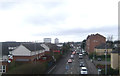
9

Houses on Walnut Road
Viewed from across Hawthorn Street (B808). Walnut Street once joined onto the main road, but is now separated by a series of bollards.
Image: © Richard Sutcliffe
Taken: 2 Mar 2017
0.09 miles
10
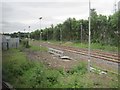
Cowlairs West railway Junction
View south towards Glasgow Queen Street just prior to electrification of the line. Because of the extensive engineering work, passenger trains were unusually being diverted onto the Springburn to Bishopbriggs line, from where the image was taken.
Image: © Nigel Thompson
Taken: 6 Jul 2016
0.10 miles