IMAGES TAKEN NEAR TO
Cockmuir Street, GLASGOW, G21 4XF
Introduction
This page details the photographs taken nearby to Cockmuir Street, G21 4XF by members of the Geograph project.
The Geograph project started in 2005 with the aim of publishing, organising and preserving representative images for every square kilometre of Great Britain, Ireland and the Isle of Man.

There are currently over 7.5m images from over14,400 individuals and you can help contribute to the project by visiting https://www.geograph.org.uk
Image Map
Images are licensed for reuse under creativecommons.org/licenses/by-sa/2.0
Notes
- Clicking on the map will re-center to the selected point.
- The higher the marker number, the further away the image location is from the centre of the postcode.
Image Listing (13 Images Found)
Images are licensed for reuse under creativecommons.org/licenses/by-sa/2.0
Image
Details
Distance
1
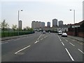
Broomfield Road
Looking to the Red Road flats.
Image: © Stephen Sweeney
Taken: 20 Apr 2009
0.11 miles
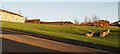
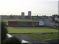
2
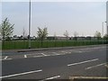
Football pitches in Broomfield Park
From Broomfield Road.
Image: © Stephen Sweeney
Taken: 20 Apr 2009
0.14 miles
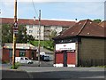
3
New Morven Bar
Seen from Edgefaulds Road.
Image: © Richard Webb
Taken: 16 Jun 2011
0.15 miles
5
New Morven Bar
Pub in Old Balornock.
Image: © Stephen Sweeney
Taken: 20 Apr 2009
0.17 miles
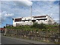
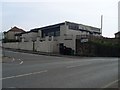
6
North Glasgow College building, Edgefauld Road
This looks like a former shop.
Image: © Richard Webb
Taken: 20 Jun 2011
0.17 miles
7
Old foundations in Springburn
Between Wellfield Street and Edgefauld Road.
Image: © Thomas Nugent
Taken: 1 Dec 2012
0.21 miles
8
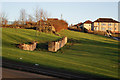
Old foundations in Springburn
Between Wellfield Street and Edgefauld Road.
Image: © Thomas Nugent
Taken: 1 Dec 2012
0.21 miles
10
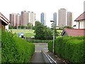
Path between Menzies Road and Wallacewell Road
With a view towards the Red Road flats.
Image: © Richard Webb
Taken: 16 Jun 2011
0.23 miles