IMAGES TAKEN NEAR TO
Cornhill Street, GLASGOW, G21 4UN
Introduction
This page details the photographs taken nearby to Cornhill Street, G21 4UN by members of the Geograph project.
The Geograph project started in 2005 with the aim of publishing, organising and preserving representative images for every square kilometre of Great Britain, Ireland and the Isle of Man.

There are currently over 7.5m images from over14,400 individuals and you can help contribute to the project by visiting https://www.geograph.org.uk
Image Map
Images are licensed for reuse under creativecommons.org/licenses/by-sa/2.0
Notes
- Clicking on the map will re-center to the selected point.
- The higher the marker number, the further away the image location is from the centre of the postcode.
Image Listing (35 Images Found)
Images are licensed for reuse under creativecommons.org/licenses/by-sa/2.0
Image
Details
Distance
1
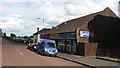
Drumbottie Stores
Shop on Campsie Street, Springburn.
Image: © Richard Webb
Taken: 16 Jun 2011
0.12 miles
2
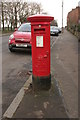
George V Pillar box
Postbox number G21 72, beside the junction of Broomfield Road and Syriam Street.
Image: © Richard Sutcliffe
Taken: 9 Mar 2017
0.15 miles
3
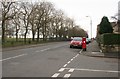
Broomfield Road
George V pillar box beside the junction with Syriam Street. Springburn Park is to the left.
Image: © Richard Sutcliffe
Taken: 9 Mar 2017
0.15 miles
4
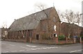
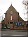
Immaculate Heart of Mary church
Category B listed Roman Catholic church at the corner of Broomfield Road and Syriam Street, built in 1950-52.
Image: © Richard Sutcliffe
Taken: 9 Mar 2017
0.15 miles
5
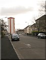
Syriam Street
Looking south towards the Wellfield flats off Reidhouse Street.
Image: © Richard Sutcliffe
Taken: 9 Mar 2017
0.15 miles
6
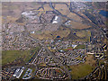
Bolornock from the air
Stobhill Hospital is in the lower left corner. Wallacewell Road runs through the centre of the photo, the M80 motorway is in the top right corner.
Image: © Thomas Nugent
Taken: 19 Mar 2018
0.16 miles
7
Immaculate Heart of Mary church
Category B listed Roman Catholic church at the corner of Broomfield Road and Syriam Street, built in 1950-52.
Image: © Richard Sutcliffe
Taken: 9 Mar 2017
0.17 miles
8
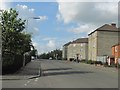
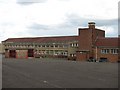
Syriam Street
Street in Springburn, with Springburn Academy on the left.
Image: © Richard Webb
Taken: 16 Jun 2011
0.18 miles
9
St Martha's R.C. Primary School
Off Menzies Road, Old Balornock.
Image: © Richard Webb
Taken: 16 Jun 2011
0.18 miles
10
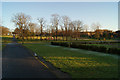
Springburn Park
The south end of the park, looking towards Broomfield Road.
Image: © Thomas Nugent
Taken: 1 Dec 2012
0.22 miles