IMAGES TAKEN NEAR TO
Atlas Road, GLASGOW, G21 4TP
Introduction
This page details the photographs taken nearby to Atlas Road, G21 4TP by members of the Geograph project.
The Geograph project started in 2005 with the aim of publishing, organising and preserving representative images for every square kilometre of Great Britain, Ireland and the Isle of Man.

There are currently over 7.5m images from over14,400 individuals and you can help contribute to the project by visiting https://www.geograph.org.uk
Image Map
Images are licensed for reuse under creativecommons.org/licenses/by-sa/2.0
Notes
- Clicking on the map will re-center to the selected point.
- The higher the marker number, the further away the image location is from the centre of the postcode.
Image Listing (97 Images Found)
Images are licensed for reuse under creativecommons.org/licenses/by-sa/2.0
Image
Details
Distance
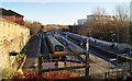
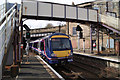
1
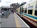
Train just arrived at Springburn station
Looking along the platform to the entrance building on Atlas Road.
Image: © Stephen Sweeney
Taken: 27 May 2009
0.01 miles
2
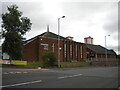
Springburn Parish Church, Atlas Road, Springburn
Image: © Richard Vince
Taken: 12 Sep 2022
0.01 miles
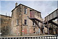
3
Springburn Railway Station
On Atlas Street. The building is three storeys tall at the platform side as can be seen in this other photo Image
Image: © Thomas Nugent
Taken: 28 Mar 2010
0.02 miles
4
Springburn Railway Station
The station building is three storeys high at the platform side. See the street side of the building here Image
Image: © Thomas Nugent
Taken: 28 Mar 2010
0.02 miles
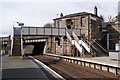
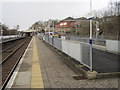
5
Springburn railway station
The view from the footbridge. The station has four platforms, two bay platforms and two through platforms.
Image: © Thomas Nugent
Taken: 1 Dec 2012
0.02 miles
6
Springburn Railway Station
A curious arrangement of footbridges links the platforms, ticket office and the outside world.
Image: © Thomas Nugent
Taken: 28 Mar 2010
0.02 miles
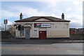
7
South end of Springburn Way, Springburn
Off Atlas Road.
Image: © Richard Vince
Taken: 12 Sep 2022
0.02 miles
8
Springburn railway station, Glasgow
Opened in 1887 by the City of Glasgow Union Railway, later part of the North British Railway, on the line from Bellgrove.
View north west following electrification of the through lines. The lines on the far right end at buffer stops. The through lines on these platforms curve sharply left towards Glasgow Queen Street (High Level) station.
Image: © Nigel Thompson
Taken: 15 Jan 2020
0.02 miles
9
Springburn Railway Station
A Queen Street bound train is just leaving Platform 1 and will branch off to the left shortly after passing under the second bridge.
Image: © Thomas Nugent
Taken: 28 Mar 2010
0.02 miles
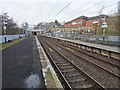
10
Springburn railway station, Glasgow, 2013
Opened in 1887 by the City of Glasgow Union Railway, later part of the North British Railway, on the line from Bellgrove.
View north west, a few months before the through lines were also electrified - see Image for a 2020 view. The lines on the right end at buffer stops. The through lines on the left curve sharply left towards Glasgow Queen Street (High Level) station.
Image: © Nigel Thompson
Taken: 15 Mar 2013
0.03 miles