IMAGES TAKEN NEAR TO
Mollinsburn Street, GLASGOW, G21 4SE
Introduction
This page details the photographs taken nearby to Mollinsburn Street, G21 4SE by members of the Geograph project.
The Geograph project started in 2005 with the aim of publishing, organising and preserving representative images for every square kilometre of Great Britain, Ireland and the Isle of Man.

There are currently over 7.5m images from over14,400 individuals and you can help contribute to the project by visiting https://www.geograph.org.uk
Image Map
Images are licensed for reuse under creativecommons.org/licenses/by-sa/2.0
Notes
- Clicking on the map will re-center to the selected point.
- The higher the marker number, the further away the image location is from the centre of the postcode.
Image Listing (117 Images Found)
Images are licensed for reuse under creativecommons.org/licenses/by-sa/2.0
Image
Details
Distance
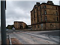
1
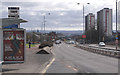
Springburn Road
Looking south towards the city centre, near the entrance to St Rollox retail park.
Image: © Thomas Nugent
Taken: 28 Mar 2010
0.02 miles
2
Ayr Street
At the junction with Flemington Street.
Image: © Thomas Nugent
Taken: 28 Mar 2010
0.05 miles
3
Old building of North Glasgow College
A new building is nearing completion at a site just to the north of here.
Image: © Stephen Sweeney
Taken: 20 Apr 2009
0.08 miles
4
Springburn Road
Viewed from the junction with the new Springburn Road.
Image: © Thomas Nugent
Taken: 28 Mar 2010
0.09 miles
5
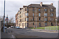
Old Fire Station Springburn
The old tenement was the Springburn Fire station until the construction of a new station I believe in the late 70's. If you look closely you can see the infill of the original station openings on the ground floor which now have windows set in. The building has been converted to flats. I am led to believe families of the Firemen lived in the flats above and a brick built block of flats sit just to the right and behind the building, also used as housing for families.
The line of the original Springburn Road can be seen to the left of the station building, the road was re-aligned and made a Dual carriageway in the early 80's. The new North bound carriageway is seen to the far left. 24th July 2009 10.15 a.m.
Image: © Gordon Dowie
Taken: 24 Jul 2009
0.09 miles
6
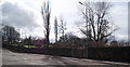
Sighthill Cemetery
Viewed from Springburn Road.
Image: © Thomas Nugent
Taken: 28 Mar 2010
0.09 miles
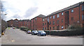
8
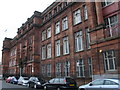
North Glasgow College
This building wasn't always a seat of learning, originally being built in 1909 as the Administrative and Drawing Offices of the former North British Locomotive Company of Scotland. Directly across the street (to the left of picture) was the Hyde Park Works, where many railway engines were built. In a strange quirk of fate, after the old locomotive works were demolished and the site cleared, it is the college that is expanding, and a new campus is being built to replace the current red standstone building.
Image: © Raymond Okonski
Taken: 18 Sep 2007
0.11 miles
9
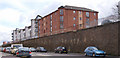
Springburn Road
A high retaining wall on the south side of the road.
Image: © Thomas Nugent
Taken: 28 Mar 2010
0.11 miles
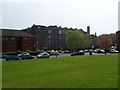
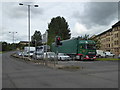
10

North Glasgow College - New Campus
This site was previously the home to the North British Railway Locomotive Hyde Park Works, where many railway engines were built. The North Glasgow College took over the original Administration and Drawing Office directly opposite, and will be moving to this new site once construction is complete in 2008.
Image: © Raymond Okonski
Taken: 18 Sep 2007
0.11 miles