IMAGES TAKEN NEAR TO
Midton Street, GLASGOW, G21 4RR
Introduction
This page details the photographs taken nearby to Midton Street, G21 4RR by members of the Geograph project.
The Geograph project started in 2005 with the aim of publishing, organising and preserving representative images for every square kilometre of Great Britain, Ireland and the Isle of Man.

There are currently over 7.5m images from over14,400 individuals and you can help contribute to the project by visiting https://www.geograph.org.uk
Image Map
Images are licensed for reuse under creativecommons.org/licenses/by-sa/2.0
Notes
- Clicking on the map will re-center to the selected point.
- The higher the marker number, the further away the image location is from the centre of the postcode.
Image Listing (89 Images Found)
Images are licensed for reuse under creativecommons.org/licenses/by-sa/2.0
Image
Details
Distance
1

Tenement Flats, Midton Street, Glasgow
Image: © Leslie Barrie
Taken: 21 Nov 2013
0.01 miles
2

Petershill Park
A new football stadium off Petershill Road.
Image: © Thomas Nugent
Taken: 28 Mar 2010
0.05 miles
3

Petershill Park
A new football stadium off Petershill Road.
Image: © Thomas Nugent
Taken: 28 Mar 2010
0.06 miles
4
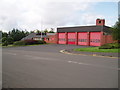
Springburn Fire Station
The local Fire Station just off Petershill Road, Springburn, Glasgow. 29th July 2009 9.45a.m.
Image: © Gordon Dowie
Taken: 29 Jul 2009
0.06 miles
5

Auchentoshan Terrace
The gatehouse at Sighthill Cemetery, across Springburn Road, is visible in the distance.
Image: © Thomas Nugent
Taken: 28 Mar 2010
0.07 miles
6

Petershill Park
Football is the game of choice here, with a new stadium to the right and six new five-a-side pitches to the left.
Image: © Thomas Nugent
Taken: 28 Mar 2010
0.08 miles
7
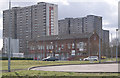
Sighthill high rise blocks
The red brick building is the former British Rail Engineering Ltd (BREL) building on Springburn Road.
Image: © Thomas Nugent
Taken: 28 Mar 2010
0.10 miles
8

Barony Medical Centre
On Petershill Road at Auchinloch Street.
Image: © Thomas Nugent
Taken: 28 Mar 2010
0.12 miles
9

Petershill Park
A swingpark in a corner of the park, with the Red Road Flats and Provan Gas Works visible on the horizon.
Image: © Thomas Nugent
Taken: 28 Mar 2010
0.12 miles
10
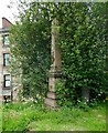
A disappearing monument
This obelisk, in memorial to members of a Victorian family by the name of King, is gradually disappearing into the vegetation. Although Sighthill Cemetery is Category B listed http://portal.historicenvironment.scot/designation/LB33623, it is need of considerable attention as regards to maintenance. No doubt this is due to Glasgow City Council's lack of staff and funds at this time.
Image: © Richard Sutcliffe
Taken: 24 Jul 2020
0.13 miles