IMAGES TAKEN NEAR TO
Yew Drive, GLASGOW, G21 4EF
Introduction
This page details the photographs taken nearby to Yew Drive, G21 4EF by members of the Geograph project.
The Geograph project started in 2005 with the aim of publishing, organising and preserving representative images for every square kilometre of Great Britain, Ireland and the Isle of Man.

There are currently over 7.5m images from over14,400 individuals and you can help contribute to the project by visiting https://www.geograph.org.uk
Image Map
Images are licensed for reuse under creativecommons.org/licenses/by-sa/2.0
Notes
- Clicking on the map will re-center to the selected point.
- The higher the marker number, the further away the image location is from the centre of the postcode.
Image Listing (29 Images Found)
Images are licensed for reuse under creativecommons.org/licenses/by-sa/2.0
Image
Details
Distance
1
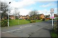
Houses on Foresthall Drive
Seen from the junction with Edgefauld Road.
Image: © Richard Sutcliffe
Taken: 2 Mar 2017
0.09 miles
2
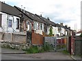
Foyers Terrace Lane
Secured lane behind a row of small houses off Edgefaulds Road.
Image: © Richard Webb
Taken: 16 Jun 2011
0.12 miles
3
Edgefauld Road
Viewed from the junction with Edgefauld Drive.
Image: © Richard Sutcliffe
Taken: 2 Mar 2017
0.12 miles
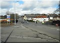
4
Junction of Edgefauld Road and Edgefauld Drive
The sign on the left advertises 'Burger Van Open - Next Left', and it can be seen parked part way down Edgefauld Drive on the right hand side, where it was doing a steady trade.
Image: © Richard Sutcliffe
Taken: 2 Mar 2017
0.12 miles
5
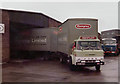
Remploy Factory Springburn
This picture was taken in 1978 at the Remploy factory in Springburn when in those days all the manufactured products were transported
to the distribution warehouse in Oldham Lancashire by vehicles like these.
In 1978 this factory used to make chairs for offices and schools.
Remploy was set up under the 1944 Disabled Persons Employment Act by Ernest Bevin, who was then minister of labour.
The firm was formally founded in April 1945 and its first factory opened in Bridgend, South Wales, in 1946 where it made violins and furniture and many of the workers were disabled miners.
Derived from 're-employ', the name was adopted by Remploy in 1946; before then it was called the Disabled Persons Employment Corporation.
From its beginnings more than 60 years ago, the company developed a factory network throughout the UK which operated in a diverse variety of businesses.
Remploy's work has included the manufacture of motor components, school furniture and making chemical, biological and nuclear protection suits for police and military in the UK and overseas.
In 2007 Remploy was in the news after an announcement was made of plans to close 43 factories around the UK.http://www.communitycare.co.uk/Articles/2009/03/03/110872/remploy.html
two of which can be seen below
Image
Image
Image: © Paul Anderson
Taken: Unknown
0.14 miles
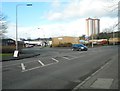
6
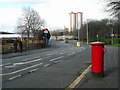
Edgefauld Road
Looking past the pedestrian only entrance to Barnhill railway station on the left towards the tall Newlands and Wellfield flats in the distance. The pillar box in the foreground is postbox number G21 214D [http://www.geograph.org.uk/photo/5300352].
Image: © Richard Sutcliffe
Taken: 2 Mar 2017
0.14 miles
7
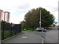
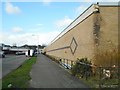
Haig Street
Haig Street leaves Edgefauld Road. In the acute angle between the streets there is a grove of horse chestnuts. The western side of the trees are brown, due to mechanical damage to the leaves during a gale on the 23rd May 2011. The site is very exposed to the west, Edgefauld Road is a steep hill. Some trees had suffered more permanent damage.
Image: © Richard Webb
Taken: 16 Jun 2011
0.15 miles
8
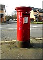
Pillar box on Edgefauld Road
Postbox number G21 214D.
Image: © Richard Sutcliffe
Taken: 2 Mar 2017
0.15 miles
9
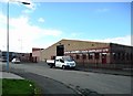
Atlas Industrial Estate, Edgefauld Drive
The van at the side of the road is selling burgers.
Image: © Richard Sutcliffe
Taken: 2 Mar 2017
0.15 miles
10
John Adams (Coach Supplies) Ltd
On Edgefauld Avenue.
Image: © Richard Sutcliffe
Taken: 2 Mar 2017
0.18 miles