IMAGES TAKEN NEAR TO
Darnick Street, GLASGOW, G21 4BA
Introduction
This page details the photographs taken nearby to Darnick Street, G21 4BA by members of the Geograph project.
The Geograph project started in 2005 with the aim of publishing, organising and preserving representative images for every square kilometre of Great Britain, Ireland and the Isle of Man.

There are currently over 7.5m images from over14,400 individuals and you can help contribute to the project by visiting https://www.geograph.org.uk
Image Map
Images are licensed for reuse under creativecommons.org/licenses/by-sa/2.0
Notes
- Clicking on the map will re-center to the selected point.
- The higher the marker number, the further away the image location is from the centre of the postcode.
Image Listing (5 Images Found)
Images are licensed for reuse under creativecommons.org/licenses/by-sa/2.0
Image
Details
Distance
1

Petershill Road looking towards Red Road Tower Blocks
Image: © Chris Upson
Taken: 10 Feb 2006
0.04 miles
2
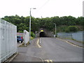
Road Tunnel
Very low but long tunnel (about 80m) controlled by Traffic lights on Darnick Street Glasgow. The overgrown embankment hides an active train line. 28th July 2009 3.45p.m.
Image: © Gordon Dowie
Taken: 28 Jul 2009
0.12 miles
3
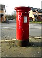
Pillar box on Edgefauld Road
Postbox number G21 214D.
Image: © Richard Sutcliffe
Taken: 2 Mar 2017
0.23 miles
4
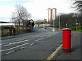
Edgefauld Road
Looking past the pedestrian only entrance to Barnhill railway station on the left towards the tall Newlands and Wellfield flats in the distance. The pillar box in the foreground is postbox number G21 214D [http://www.geograph.org.uk/photo/5300352].
Image: © Richard Sutcliffe
Taken: 2 Mar 2017
0.23 miles
5
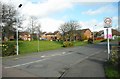
Houses on Foresthall Drive
Seen from the junction with Edgefauld Road.
Image: © Richard Sutcliffe
Taken: 2 Mar 2017
0.23 miles