IMAGES TAKEN NEAR TO
Balornock Road, GLASGOW, G21 3UZ
Introduction
This page details the photographs taken nearby to Balornock Road, G21 3UZ by members of the Geograph project.
The Geograph project started in 2005 with the aim of publishing, organising and preserving representative images for every square kilometre of Great Britain, Ireland and the Isle of Man.

There are currently over 7.5m images from over14,400 individuals and you can help contribute to the project by visiting https://www.geograph.org.uk
Image Map
Images are licensed for reuse under creativecommons.org/licenses/by-sa/2.0
Notes
- Clicking on the map will re-center to the selected point.
- The higher the marker number, the further away the image location is from the centre of the postcode.
Image Listing (87 Images Found)
Images are licensed for reuse under creativecommons.org/licenses/by-sa/2.0
Image
Details
Distance
1
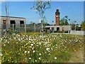
Wild flowers
A bed of wild flowers in front of the Mental Health facilities, Stobhill Hospital. In the distance is the Category B listed https://portal.historicenvironment.scot/designation/LB33289 water tower.
Image: © Richard Sutcliffe
Taken: 6 Jun 2023
0.05 miles
2
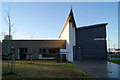
Skye House
Part of the Stobhill Hospital campus.
Image: © Thomas Nugent
Taken: 1 Dec 2012
0.06 miles
3
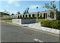
Mental Health Facilities, Stobhill
Part of the new hospital at Stobhill.
Image: © Richard Sutcliffe
Taken: 6 Jun 2023
0.06 miles
4
Belmont Pond
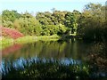
The pond is located not far to the north-east of Image, and is one of three ponds in the park; the other is Image As is explained there, Belmont Pond lies within a Site of Importance for Nature Conservation.
It lies just to the east of what was originally the villa of New Mosesfield, built in 1838 for the bookseller James Duncan; that building became Mosesfield Museum until the mid-twentieth century, after which it was used as an Old Men's Club. There was also an Old Mosesfield, not far to the south.
Also nearby, and presumably giving the pond its name, was Belmont House, which was built in 1888-89 for Hugh Reid (for whom, see Image); it was said to be Glasgow's highest house. It stood just north of New Mosesfield, but was demolished in the mid-1980s.
Image: © Lairich Rig
Taken: 11 Oct 2010
0.09 miles
5
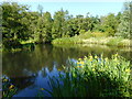
Belmont Pond, Springburn Park
One of three ponds in the park, which are part of a Site of Importance for Nature Conservation (SINC).
Image: © Richard Sutcliffe
Taken: 6 Jun 2023
0.09 miles
6
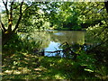
Belmont Pond, Springburn Park
One of three ponds in the park, which are part of a Site of Importance for Nature Conservation (SINC).
Image: © Richard Sutcliffe
Taken: 6 Jun 2023
0.09 miles
7
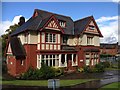
The Old Refectory
The Old Refectory, Stobhill Hospital
Image: © Texas Radio and The Big Beat
Taken: 21 Aug 2014
0.11 miles
8
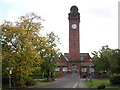
Clock Tower, Stobhill Hospital, Springburn
The hospital was designed by the architects Thomson & Sandilands and opened in 1904. Stobhill was built by the Parish of Glasgow to meet the increasing need for hospital accommodation for the city's sick poor. For many years it carried the stigma of being a hospital for paupers, and the birth certificates of babies born there only recorded the address and not the name of the hospital.
Image: © Chris Upson
Taken: 8 Oct 2005
0.11 miles
9
The Old Medical Refectory, Stobhill Hospital, Glasgow
Image: © Leslie Barrie
Taken: 29 Apr 2014
0.11 miles
10
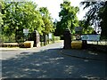
Entrance to Springburn Park
Off Belmont Road.
Image: © Richard Sutcliffe
Taken: 6 Jun 2023
0.11 miles