IMAGES TAKEN NEAR TO
Menzies Road, GLASGOW, G21 3LY
Introduction
This page details the photographs taken nearby to Menzies Road, G21 3LY by members of the Geograph project.
The Geograph project started in 2005 with the aim of publishing, organising and preserving representative images for every square kilometre of Great Britain, Ireland and the Isle of Man.

There are currently over 7.5m images from over14,400 individuals and you can help contribute to the project by visiting https://www.geograph.org.uk
Image Map
Images are licensed for reuse under creativecommons.org/licenses/by-sa/2.0
Notes
- Clicking on the map will re-center to the selected point.
- The higher the marker number, the further away the image location is from the centre of the postcode.
Image Listing (12 Images Found)
Images are licensed for reuse under creativecommons.org/licenses/by-sa/2.0
Image
Details
Distance
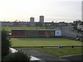
1
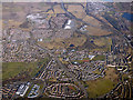
Bolornock from the air
Stobhill Hospital is in the lower left corner. Wallacewell Road runs through the centre of the photo, the M80 motorway is in the top right corner.
Image: © Thomas Nugent
Taken: 19 Mar 2018
0.04 miles
2
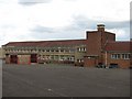
St Martha's R.C. Primary School
Off Menzies Road, Old Balornock.
Image: © Richard Webb
Taken: 16 Jun 2011
0.06 miles
3
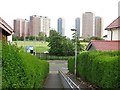
Path between Menzies Road and Wallacewell Road
With a view towards the Red Road flats.
Image: © Richard Webb
Taken: 16 Jun 2011
0.16 miles
4
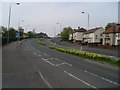
Wallacewell Road
Heading south, towards Springburn and the City Centre.
Image: © Stephen Sweeney
Taken: 20 Apr 2009
0.18 miles
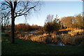
6
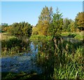
Stobhill Pond
For another view, see Image
This pond is located not far to the north-east of Image, and is one of three in the park; the other is Image
Stobhill and Belmont Ponds are located within an area that has been designated a Site of Importance for Nature Conservation, and which is managed to encourage the presence of wildlife. As explained at the first link in the preceding paragraph, they were created some time after the boating pond.
Image: © Lairich Rig
Taken: 11 Oct 2010
0.24 miles
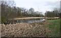
7
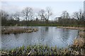
Boating pond, Springburn Park
The pond has been partly naturalised, to encourage wildlife, and is part of a Site of Importance for Nature Conservation (SINC).
Image: © Richard Sutcliffe
Taken: 9 Mar 2017
0.25 miles
8
Springburn Park
The lake at the north east corner of the park.
Image: © Thomas Nugent
Taken: 1 Dec 2012
0.25 miles
9
Springburn Park
The lake at the north east corner of the park.
Image: © Thomas Nugent
Taken: 1 Dec 2012
0.25 miles
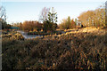
10
Wildlife pond, Springburn Park
One of three ponds in the park, which are part of a Site of Importance for Nature Conservation (SINC). A pair of mute swans are in residence.
Image: © Richard Sutcliffe
Taken: 9 Mar 2017
0.25 miles