IMAGES TAKEN NEAR TO
Ryemount Road, GLASGOW, G21 3EQ
Introduction
This page details the photographs taken nearby to Ryemount Road, G21 3EQ by members of the Geograph project.
The Geograph project started in 2005 with the aim of publishing, organising and preserving representative images for every square kilometre of Great Britain, Ireland and the Isle of Man.

There are currently over 7.5m images from over14,400 individuals and you can help contribute to the project by visiting https://www.geograph.org.uk
Image Map
Images are licensed for reuse under creativecommons.org/licenses/by-sa/2.0
Notes
- Clicking on the map will re-center to the selected point.
- The higher the marker number, the further away the image location is from the centre of the postcode.
Image Listing (17 Images Found)
Images are licensed for reuse under creativecommons.org/licenses/by-sa/2.0
Image
Details
Distance

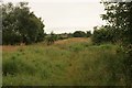
2
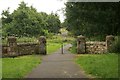
Entrance to Robroyston Park Local Nature Reserve
Much of the Park has been a Local Nature Reserve (LNR) since 2006. Glasgow City Council has extended the boundary of the LNR twice since then. In May 2016 the whole Park was designated as a LNR.
Image: © Richard Sutcliffe
Taken: 5 Aug 2016
0.08 miles
4
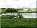
Pool, Robroyston Park Nature Reserve
A shallow pool in a bit of wild land. A good birding spot with a grasshopper warbler reeling while I took this.
Image: © Richard Webb
Taken: 16 Jun 2011
0.15 miles
5
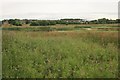
Robroyston Park Local Nature Reserve
Much of the Park has been a Local Nature Reserve (LNR) since 2006. Glasgow City Council has extended the boundary of the LNR twice since then. In May 2016 the whole Park was designated as a LNR.
Image: © Richard Sutcliffe
Taken: 5 Aug 2016
0.16 miles
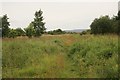
6
Robroyston Park Local Nature Reserve
Much of the Park has been a Local Nature Reserve (LNR) since 2006. Glasgow City Council has extended the boundary of the LNR twice since then. In May 2016 the whole Park was designated as a LNR.
Image: © Richard Sutcliffe
Taken: 5 Aug 2016
0.19 miles
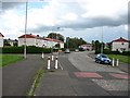
7
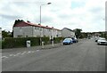
Ryehill Road, Barmulloch
The road on the left is Bishopmill Place.
Image: © Richard Sutcliffe
Taken: 16 Jul 2021
0.19 miles
8
Robroyston Park Local Nature Reserve
Much of the Park has been a Local Nature Reserve (LNR) since 2006. Glasgow City Council has extended the boundary of the LNR twice since then. In May 2016 the whole Park was designated as a LNR.
Image: © Richard Sutcliffe
Taken: 5 Aug 2016
0.19 miles
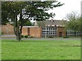
9
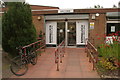
Barmulloch Community Centre and Library
The welcoming entrance to one of Glasgow's Community Hubs.
Image: © Richard Sutcliffe
Taken: 5 Aug 2016
0.19 miles
10
Library, Rockfield Road
I am not sure if it is still open or not.
Image: © Richard Webb
Taken: 16 Jun 2011
0.19 miles