IMAGES TAKEN NEAR TO
Berryburn Road, GLASGOW, G21 3DA
Introduction
This page details the photographs taken nearby to Berryburn Road, G21 3DA by members of the Geograph project.
The Geograph project started in 2005 with the aim of publishing, organising and preserving representative images for every square kilometre of Great Britain, Ireland and the Isle of Man.

There are currently over 7.5m images from over14,400 individuals and you can help contribute to the project by visiting https://www.geograph.org.uk
Image Map
Images are licensed for reuse under creativecommons.org/licenses/by-sa/2.0
Notes
- Clicking on the map will re-center to the selected point.
- The higher the marker number, the further away the image location is from the centre of the postcode.
Image Listing (17 Images Found)
Images are licensed for reuse under creativecommons.org/licenses/by-sa/2.0
Image
Details
Distance
1
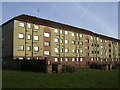
Derelict Housing, Bucksburn Road, Balornock
Image: © Chris Upson
Taken: 10 Feb 2006
0.07 miles
2
All Saints RC Church, Broomfield Road, Glasgow
Image: © Leslie Barrie
Taken: 29 Apr 2014
0.15 miles
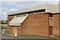
3
Broomfield Tavern, Balornock
Red Road flats behind
Image: © Chris Upson
Taken: 10 Feb 2006
0.15 miles
4
Ryehill Road, Barmulloch
The road on the left is Bishopmill Place.
Image: © Richard Sutcliffe
Taken: 16 Jul 2021
0.16 miles
5

Freight from the shipyards via Maryhill approaching Balornock Junction
View NW, towards Maryhill: probably on the Caledonian line from Clydebank etc. via Maryhill, to Dalmarnock and Robroyston (closed from Partick West 22/2/66), or possibly on another Goods branch. The train is headed by LMS Fowler 4F 0-6-0 No. 44194 (built 1925, withdrawn 12/62).
Image: © Ben Brooksbank
Taken: 5 Oct 1961
0.16 miles
6
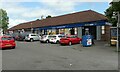
Shops, Barmulloch
On Quarrywood Avenue. The shops include Barmulloch Post Office.
Image: © Richard Sutcliffe
Taken: 16 Jul 2021
0.17 miles
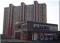
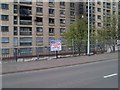
7
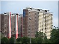
Red Road flats
The famous collection of tower blocks on the Red Road are to be demolished. The nearer block here is now in the hands of Safedem who hopefully will provide a spectacle in a few months' time.
Image: © Richard Webb
Taken: 16 Jun 2011
0.20 miles
8
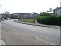
Rye Road, Balornock
Looking southeast.
Image: © Stephen Sweeney
Taken: 20 Apr 2009
0.21 miles
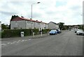
9
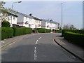
Gartons Road
Residential street just off Rye Road in Balornock.
Image: © Stephen Sweeney
Taken: 20 Apr 2009
0.22 miles
10
Demolition site at Red Road flats
The front "slab"-styled flat is in the process of being demolished.
Image: © Stephen Sweeney
Taken: 20 Apr 2009
0.22 miles