IMAGES TAKEN NEAR TO
Balgrayhill Road, GLASGOW, G21 3AF
Introduction
This page details the photographs taken nearby to Balgrayhill Road, G21 3AF by members of the Geograph project.
The Geograph project started in 2005 with the aim of publishing, organising and preserving representative images for every square kilometre of Great Britain, Ireland and the Isle of Man.

There are currently over 7.5m images from over14,400 individuals and you can help contribute to the project by visiting https://www.geograph.org.uk
Image Map
Images are licensed for reuse under creativecommons.org/licenses/by-sa/2.0
Notes
- Clicking on the map will re-center to the selected point.
- The higher the marker number, the further away the image location is from the centre of the postcode.
Image Listing (89 Images Found)
Images are licensed for reuse under creativecommons.org/licenses/by-sa/2.0
Image
Details
Distance
1
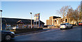
Parkgate shops
With the derelict Talisman bar in the background.
Image: © Thomas Nugent
Taken: 1 Dec 2012
0.01 miles
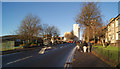
2
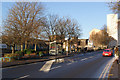
Balgrayhill Road
Looking north, near Balgrayhill Community Hall.
Image: © Thomas Nugent
Taken: 1 Dec 2012
0.03 miles
3
Balgrayhill Road
Looking north, near Balgrayhill Community Hall.
Image: © Thomas Nugent
Taken: 1 Dec 2012
0.03 miles
4
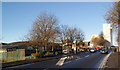
Balgrayhill Road
Looking towards Parkgate shops.
Image: © Thomas Nugent
Taken: 1 Dec 2012
0.03 miles
5
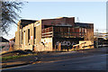
The Talisman
Vandal magnet on Balgrayhill Road. Appears to have been derelict for some time.
Image: © Thomas Nugent
Taken: 1 Dec 2012
0.03 miles
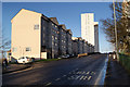
6
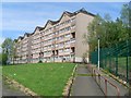
Lenzie Terrace
Flats in Springburn.
Image: © Stephen Sweeney
Taken: 27 May 2009
0.05 miles
8
Balgrayhill Road
Looking north from the bus stop at The Talisman.
Image: © Thomas Nugent
Taken: 1 Dec 2012
0.07 miles