IMAGES TAKEN NEAR TO
Blochairn Road, GLASGOW, G21 2RT
Introduction
This page details the photographs taken nearby to Blochairn Road, G21 2RT by members of the Geograph project.
The Geograph project started in 2005 with the aim of publishing, organising and preserving representative images for every square kilometre of Great Britain, Ireland and the Isle of Man.

There are currently over 7.5m images from over14,400 individuals and you can help contribute to the project by visiting https://www.geograph.org.uk
Image Map
Images are licensed for reuse under creativecommons.org/licenses/by-sa/2.0
Notes
- Clicking on the map will re-center to the selected point.
- The higher the marker number, the further away the image location is from the centre of the postcode.
Image Listing (24 Images Found)
Images are licensed for reuse under creativecommons.org/licenses/by-sa/2.0
Image
Details
Distance
1
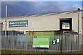
Glasgow Waste Transfer Station & Materials Recycling Facility
Image: © Leslie Barrie
Taken: 21 Nov 2013
0.10 miles
2
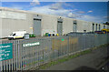
Blochairn Recycling Facility
A Glasgow City Council facility on Blochairn Road.
Image: © Thomas Nugent
Taken: 24 Aug 2022
0.11 miles
3
Railway tunnel north of Alexandra Parade station
On the line to Springburn, just north of the M8.
Image: © Stephen Sweeney
Taken: 21 Apr 2009
0.12 miles
4
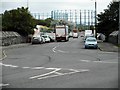
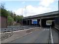
Blochairn Road
A Tesco lorry heads down the road towards the Category B listed gasholders at the site of the former Provan Gasworks. The gasholders are the largest ever built in Scotland. See http://portal.historicenvironment.scot/designation/LB52442 for a lot more information.
Image: © Richard Sutcliffe
Taken: 23 Aug 2019
0.13 miles
5
M8 crosses the B763
Just north of Alexandra Park.
Image: © Stephen Sweeney
Taken: 21 Apr 2009
0.14 miles
6
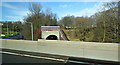
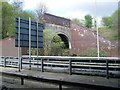
Blochairn railway tunnel
The south portal of the 110 yards long tunnel which is on the line between Belgrove and Springburn. Viewed from the M8 motorway.
Image: © Thomas Nugent
Taken: 23 Feb 2020
0.15 miles
7
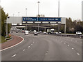
M8, Glasgow
Note the typical “Glasgow-type” sign gantry giving advance notice of the next junction (junction 13). With the following distinctive elements:
• Near and offside support legs (basically 2 rectangular hollow sections with base plates to allow connections to the foundations)
• A Main Frame (made up of rectangular hollow sections) - Over clad on the front and rear.
• A Sub Frame (made up of smaller hollow sections and welded to main frame).
• A Sign Face - acrylic sheets hung from the front of the sub frame over its full height.
• Internal Electrics - sign lighting provided through the use of several dozen fluorescent battens.
Gantries of this type were erected as part of the construction of the Kingston Bridge and its approach roads in 1970 and they are now a familiar sight on the network around Glasgow.
More information on “Glasgow Style Gantries” at http://www.glasgows-motorways.co.uk/glasgow-gantries/4578281645 (Glasgow’s Motorways)
Image: © David Dixon
Taken: 20 Apr 2012
0.15 miles
8
Looking to Germiston highrise flats
From the walkway at junction 14 of the M8.
Image: © Stephen Sweeney
Taken: 21 Apr 2009
0.16 miles
9
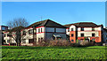
Sandmill Street
Modern housing in Glasgow's Germiston area.
Image: © Mary and Angus Hogg
Taken: 22 Nov 2014
0.17 miles
10
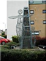
Sculpture, Cloverbank Gardens
Created for Blochairn Housing Association in 2002 by sculptor Andy Scott, better known for 'The Kelpies'. The stone cairn represents Blochairn, which means 'place of stones' and the people figures have open arms welcoming you to the Blochairn community.
Image: © Richard Sutcliffe
Taken: 23 Aug 2019
0.17 miles