IMAGES TAKEN NEAR TO
Royston Road, GLASGOW, G21 2QU
Introduction
This page details the photographs taken nearby to Royston Road, G21 2QU by members of the Geograph project.
The Geograph project started in 2005 with the aim of publishing, organising and preserving representative images for every square kilometre of Great Britain, Ireland and the Isle of Man.

There are currently over 7.5m images from over14,400 individuals and you can help contribute to the project by visiting https://www.geograph.org.uk
Image Map
Images are licensed for reuse under creativecommons.org/licenses/by-sa/2.0
Notes
- Clicking on the map will re-center to the selected point.
- The higher the marker number, the further away the image location is from the centre of the postcode.
Image Listing (59 Images Found)
Images are licensed for reuse under creativecommons.org/licenses/by-sa/2.0
Image
Details
Distance
1
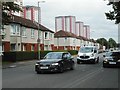
Royston Road
The tower blocks in the distance are on Charles Street.
Image: © Richard Sutcliffe
Taken: 23 Aug 2019
0.01 miles
2
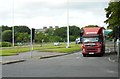
Road junction
A lorry waits at traffic lights about to turn onto Royston Road.
Image: © Richard Sutcliffe
Taken: 23 Aug 2019
0.03 miles
3
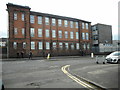
St Roch's Secondary School
On Royston Road.
Image: © Richard Sutcliffe
Taken: 23 Aug 2019
0.06 miles
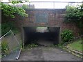
4
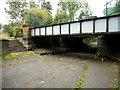
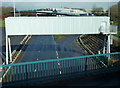
Pedestrian underpass
Now an underpass under the A803, Castle Street, this was originally a link between the Forth and Clyde and Monkland canals. A small section of the towpath survives. See Canmore https://canmore.org.uk/site/296804/glasgow-castle-street-bridge-underpass. The bridge once carried a tramway over the canal.
Image: © Richard Sutcliffe
Taken: 23 Aug 2019
0.06 miles
5
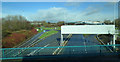
Glasgow style motorway gantry
The rear of a gantry on the A803 Springburn Road at Junction 15 of the M8. Viewed from Baird Street.
Image: © Thomas Nugent
Taken: 23 Feb 2020
0.07 miles
6
Glasgow style motorway gantry
The rear of a gantry on the A803 Springburn Road at Junction 15 of the M8. The sliproad on the right is the A804. Viewed from Baird Street.
Image: © Thomas Nugent
Taken: 23 Feb 2020
0.07 miles
7
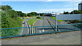
The A803 road to Springburn
Looking north from the A804.
Image: © Thomas Nugent
Taken: 9 Aug 2020
0.08 miles
8
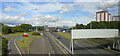
Springburn Road
The A803 road north of the M8 Junction 15 at Townhead.
Image: © Thomas Nugent
Taken: 24 Aug 2022
0.08 miles
9

Path under Castle Street
At what looks at first glance like an old railway bridge.
Image: © Stephen Sweeney
Taken: 19 Jun 2008
0.09 miles
10
Tunnel under Baird Street
Leads to Sighthill.
Image: © Stephen Sweeney
Taken: 19 Jun 2008
0.09 miles