IMAGES TAKEN NEAR TO
Charles Street, GLASGOW, G21 2QG
Introduction
This page details the photographs taken nearby to Charles Street, G21 2QG by members of the Geograph project.
The Geograph project started in 2005 with the aim of publishing, organising and preserving representative images for every square kilometre of Great Britain, Ireland and the Isle of Man.

There are currently over 7.5m images from over14,400 individuals and you can help contribute to the project by visiting https://www.geograph.org.uk
Image Map
Images are licensed for reuse under creativecommons.org/licenses/by-sa/2.0
Notes
- Clicking on the map will re-center to the selected point.
- The higher the marker number, the further away the image location is from the centre of the postcode.
Image Listing (43 Images Found)
Images are licensed for reuse under creativecommons.org/licenses/by-sa/2.0
Image
Details
Distance
1
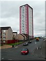
Looking up Garnock Street
The tower block is actually on Charles Street.
Image: © Richard Sutcliffe
Taken: 23 Aug 2019
0.01 miles
2
Accident Blackspot road sign
On Royston Road at Garnock Street, on the approach to St Roch's Primary School.
Image: © Thomas Nugent
Taken: 24 Aug 2022
0.06 miles
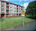
3
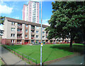
Glenconner Park
Children's play area on Royston Road.
Image: © Mary and Angus Hogg
Taken: 22 Nov 2014
0.07 miles
4
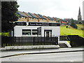
James Hardie, Funeral Services
On Royston Road. The spire of the former Townhead & Blochairn Parish Church is on the right.
Image: © Richard Sutcliffe
Taken: 23 Aug 2019
0.09 miles
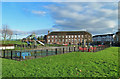
5
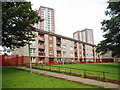
Flats, Royston Road
The tower blocks behind are on Charles Street.
Image: © Richard Sutcliffe
Taken: 23 Aug 2019
0.09 miles
6
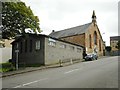
The Foundry Boys' Church at Garngad
The church is on Tharsis Street. Built in the mid-19th century, the architect is unknown. The adjacent hall was built about 15 years ago.
The Glasgow Foundry Boys' Religious Society was founded in 1865 to provide a diversion and spiritual guidance for young men (the foundry boys) who were not on the official payroll of the iron foundries, but who worked there on an ad-hoc unofficial basis. Many of these young workers tended to roam the streets, often causing a nuisance.
There were once several Foundry Boys' churches in Glasgow, but this is now the last one.
Image: © Richard Sutcliffe
Taken: 23 Aug 2019
0.09 miles
7
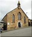
The Foundry Boys' Church at Garngad
The church is on Tharsis Street. Built in the mid-19th century, the architect is unknown. The adjacent hall was built about 15 years ago.
The Glasgow Foundry Boys' Religious Society was founded in 1865 to provide a diversion and spiritual guidance for young men (the foundry boys) who were not on the official payroll of the iron foundries, but who worked there on an ad-hoc unofficial basis. Many of these young workers tended to roam the streets, often causing a nuisance.
There were once several Foundry Boys' churches in Glasgow, but this is now the last one.
Image: © Richard Sutcliffe
Taken: 23 Aug 2019
0.09 miles
8
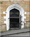
Door of the Foundry Boys' Church at Garngad
See https://www.geograph.org.uk/photo/6248345 for a wider view.
Image: © Richard Sutcliffe
Taken: 23 Aug 2019
0.09 miles
9
Flats on Royston Road
Viewed from the bus from Glasgow to Edinburgh Airport which took a short diversion from its normal route on the M8 motorway.
Image: © Thomas Nugent
Taken: 24 Aug 2022
0.10 miles
10
St Roch's RC Primary School
On Royston Road at Brodick Street, which is where the cars are parked.
Image: © Thomas Nugent
Taken: 24 Aug 2022
0.10 miles